---
title: Internet Maps
description: Collection of various visualizations of the Internet and infrastructure projects to digitize Earth for anchoring spatial web content onto.
image: https://xrdevlog.com/img/internetmaps.jpg
robots: index, follow
lang: en
dir: ltr
breaks: true
disqus: xrdevlog
---
# Maps of the Internet
###### tags: `devlog` `grid` `magicverse` `traversal`
{%hackmd theme-dark %}
Originally published July 2019
Collection of various visualizations of the Internet and infrastructure projects to digitize Earth for anchoring spatial web content onto.
> Calling the Internet "cyberspace" implies a geography, or at least a spatial aspect. And where there is a spatial aspect, there will be maps. [Source: Wired](https://www.wired.com/2015/06/mapping-the-internet/)
Good blog post: https://outofscope.bureauofbrightideas.com/a-map-of-the-metaverse/
The Opte Project, created in 2003 by Barrett Lyon, seeks to generate an accurate representation of the breadth of the Internet using visual graphics. The example below is a network map from 2003 (left) next to 2010 (right).

This map was generated by the creator of [Shodan](https://shodan.io) whom collected the data by sending ping requests to every IP address on the internet, and storing the positive responses.

The Internet Map is an impressive visualization of 350,000 websites and how they are linked to each other. Article source: [Verge](https://www.theverge.com/2012/7/30/3198825/internet-map-website-relationship)

> The Internet map is a bi-dimensional presentation of links between websites on the Internet. Every site is a circle on the map, and its size is determined by website traffic, the larger the amount of traffic, the bigger the circle. Users’ switching between websites forms links, and the stronger the link, the closer the websites tend to arrange themselves to each other. Source: <http://internet-map.net/>

- 40 maps that explain the internet <https://www.vox.com/a/internet-maps>

- Undersea cables <https://www.submarinecablemap.com/>
---
### Kaspersky
CYBERTHREAT REAL-TIME MAP: https://cybermap.kaspersky.com/

---
### Wigle
**Website: https://wigle.net/**
Location and information of wireless networks world-wide.

---
### IPFS


---
### Augmented Perception
<http://augmentedperception.com> made by [James Baicoianu](https://twitter.com/bai0)


---
### Internet Cities
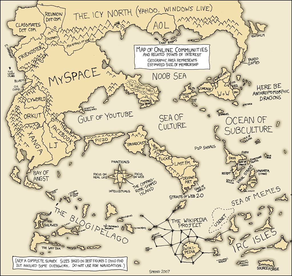
2007 XKCD Map of Online Communities
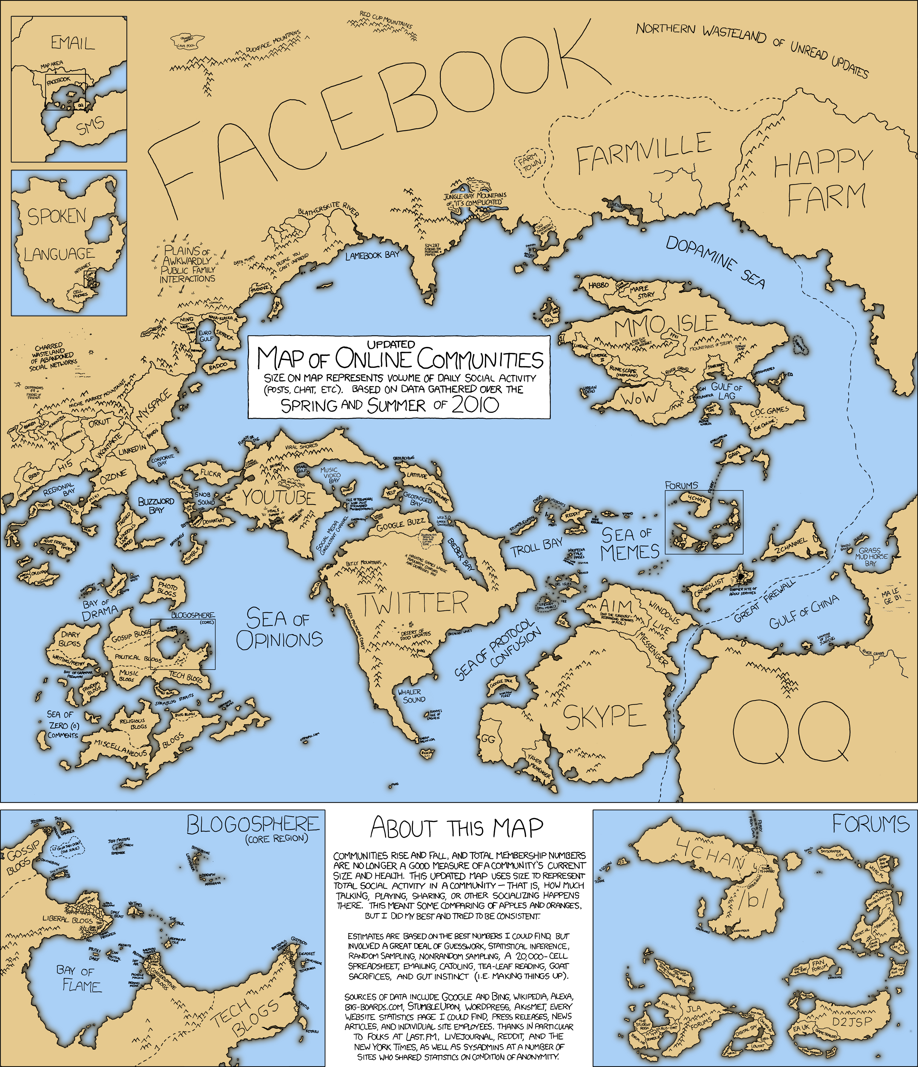
2010 XKCD Map of Online Communities
Map of Bay Area memespace, relevant since so many web companies reside there.

Map of Internet brands and phenomena


The IPV4 Space (2006)

---
## Bitmap

- https://bitmap.land/?view=vertical
- https://bitfeed.live/
---
## Cryptovoxels
https://www.cryptovoxels.com/map


**Cryptovoxels Origin City Render**

**Updated**


---
## Decentraland


https://land.decentraland.org/
---
## Alphaworld


https://personalpages.manchester.ac.uk/staff/m.dodge/cybergeography/atlas/muds_vw.html
https://mappa.mundi.net/maps/maps_013/
https://www.digitalspace.com/avatars/book/chaw/chaw7.htm
https://www.helmasawatzky.com/datatraveler/alpha.html
https://www.researchgate.net/figure/The-Morphology-of-AlphaWorld_fig5_32884862
---
## r/place
---
## Million Dollar Homepage
**[Million Dollar Homepage](http://www.milliondollarhomepage.com/) vs [/r/place](https://www.reddit.com/r/place/)**

**[Cryptovoxels](https://www.cryptovoxels.com) vs [Decentraland](https://decentraland.org) size comparison to Manhattan**

---
### The Sandbox


https://www.sandbox.game/en/land/map/
---
## Somnium Space


https://somniumspace.com/map
---
## Webaverse
https://webaverse.com/map


---
## Substrata

https://substrata.info/map
---
## Metacat
https://metacat.world/heatmap


---
## Second Life

https://maps.secondlife.com/
---
## Fortnite

https://fortnite.gg/
---
## Super Smash Bros Ultimate

https://www.ssbwiki.com/Adventure_Mode:_World_of_Light
---
### Earth 2.0
**What if the physical world was ported into the virtual?**

Concept visualizations of going from Earth into virtual worlds made with Janusweb.


---
### Mapbox
Website: <https://www.mapbox.com/>


---
### Scape
Website: <https://scape.io/technology/>
Vision Engine is built from scratch to process unstructured, unordered imagery from any source, resulting in a 3D representation of the environment stored and referenced in the cloud.

Currently a localization request takes about 2 – 3 seconds on a 3G connection. Having then localized, the system then supports various external tracking libraries such as ARKit or ARCore to track the relative position of your device to display AR content around you.


---
### Magicverse
Website: <https://www.magicleap.com/news/op-ed/magicverse>


---
### Metaverse Markets
https://medium.com/building-the-metaverse/market-map-of-the-metaverse-8ae0cde89696


---
### 6DAI
Website: <https://www.6d.ai/>
Devices using the 6D Reality Platform collectively contribute three-dimensional geometry to the AR Cloud. This builds up a machine readable form of the world’s ground-level three-dimensional data in the cloud, adding new locations that have been meshed and thus can be remembered. [Source: Successful Relocalization with 6d](https://medium.com/6d-ai/successful-relocalization-with-6d-cdf2ee4ed585)

Real-time scanning happens in the background of every app built with the 6D Reality Platform.

Relocalization happening in which location-specific data can be loaded, and tracking takes over, which is less resource-intensive.