# 2024 Newsletter items
###### tags: `board`
CONCEPT:
* short text in English in the newsletter + links to full NL/FR version on osm.be
* every three months
* at least two topics
* mapper of the month: should already provide 3 interviews!
# Topics
* Marketing – help wanted
* European Camera Grant
* News from Stéphane
* European camera thing
* Lara access
# 2024Q3
## Recap text
Hey, remember us?
We’re sorry it’s been so long since we’ve sent a newsletter about OpenStreetMap Belgium. Maybe it’s because we’ve been doing so many things.
One reason is that during 2023, OSM.be was reborn as its own independent NGO! Our umbrella organization Open Knowledge Belgium went through hard times, and is now refocusing on its core projects. We’re glad to have been part of that community, and even happier that we now have everything under the control of the OpenStreetMap community.
The new organization has been able to keep most of our corporate members: [TomTom](https://www.tomtom.com/) & [Toerisme Vlaanderen](https://toerismevlaanderen.be/) still financially support us. Thanks to Anyways.eu, we will have a stand at the next Trefdag Digitaal Vlaanderen together. [Champs Libres](https://www.champs-libres.coop/) took over the care for the [free Belgian tiles](https://openstreetmap.be/nl/projects/belgium-baselayer.html), which now are updated twice a year. And lastly, we were joined by the [Belgian National Crisis Centre](https://crisiscentrum.be/), an organization that intensively uses and improves OSM data all the time.
We’re only just over 30 people who run the organization and decide what we spend money on. If you want to be actively involved in the organizational work, just send us a quick mail via board@osm.be
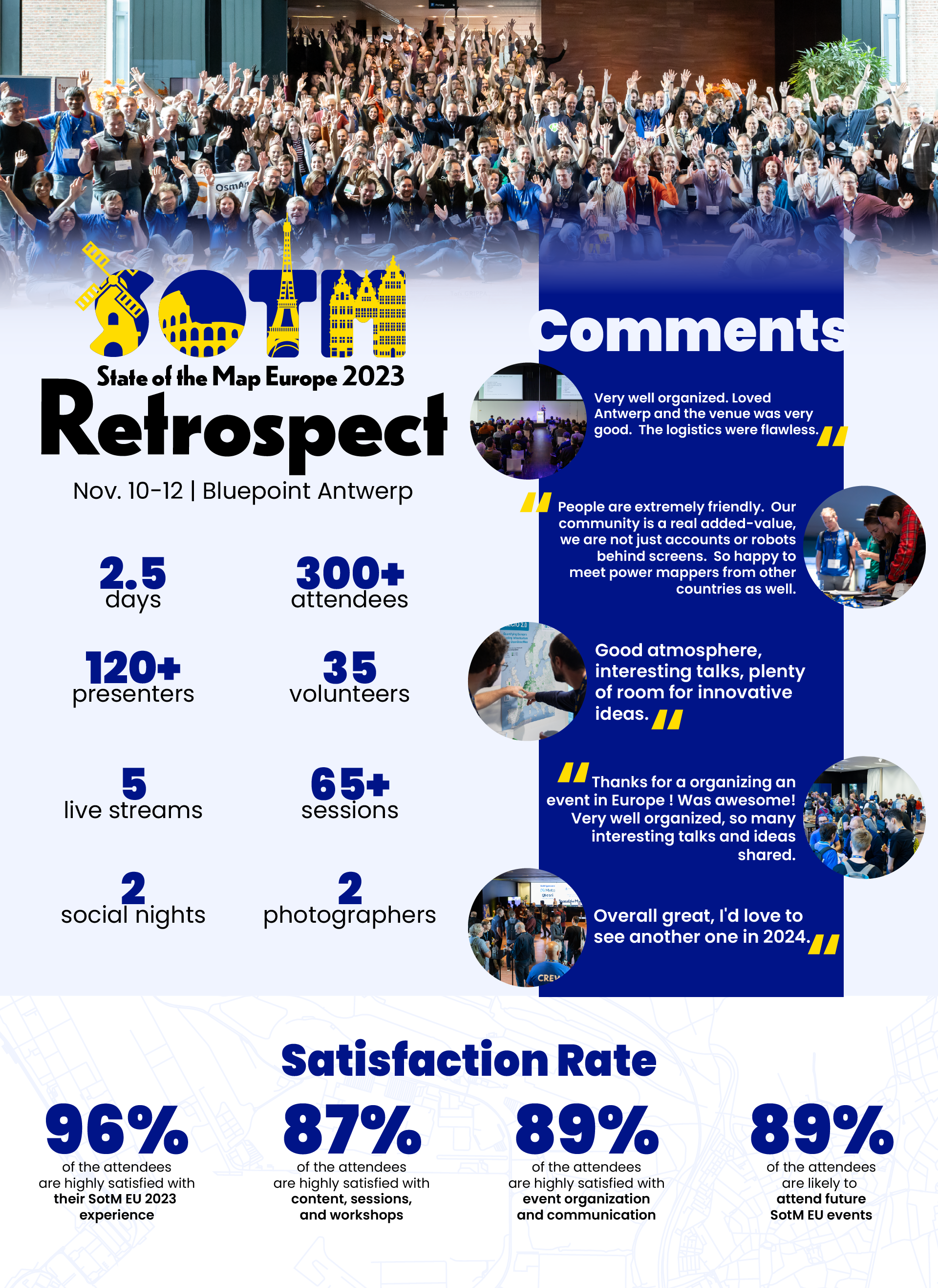
A second reason for us being busy, is that we spent a lot of time organizing [the first State of the Map Europe in a decade](https://2023.stateofthemap.eu/) in November 2023. For a long weekend, over 300 community members from around Europe and the world joined us in Antwerp for presentations and meeting each other. All the talks were recorded and can be re-watched at https://www.youtube.com/@StateoftheMapEurope
## Lili-app mapathon: 29/11 - Bruges
OpenStreetMap Belgium is organizing a mapathon in Bruges as part of our participation in the "[Lili-app project](https://amai.vlaanderen/projecten/project3-lili)". The Lili-app will help visually impaired people find and follow the best route using their smartphone. The app will take into account infrastructure such as sidewalks and pedestrian crossings and special facilities such as tactile paving and traffic lights with sound signals.
Initially, a prototype of the app will be developed that is limited to the city of Bruges. During the mapathon, we will add missing infrastructure to OpenStreetMap. Everyone is welcome. We help beginners take their first steps. There will also be more complex tasks for experienced mappers.
More info and registration via [MeetUp](https://www.meetup.com/openstreetmap-belgium/events/304083372/) or [OSMcal](https://osmcal.org/event/3228/). Catering is provided for all registered participants.
## Help us map
With OpenStreetMap data becoming ever more relevant, more and more external parties want topics of interest to them to be mapped in great detail. Do you want to help on topics that we care most about? Have a look at [the top mapping tasks](https://wiki.openstreetmap.org/wiki/WikiProject_Belgium/top_mapping_tasks) list on the wiki!
Let us just highlight two organizations we are working with.
First, [Fietsberaad Vlaanderen](https://fietsberaad.be/) is integrating their [Velopark project](https://www.velopark.be/) with OpenStreetMap. A tool was developed to easily link OSM bicycle parkings to the official data in Velopark. This will in turn make it easier to fully integrate OSM data in their tool. As a little incentive for your contributions, you can apply for volunteer fees if you contribute to the project. [More details via the forum](https://community.openstreetmap.org/t/mapping-of-bicycle-parkings-collaboration-with-fietsberaad-vlaanderen/116182).
Second, our corporate member the Belgian National Crisis Centre, intensively uses OpenStreetMap data in their crisis management application Paragon. With help from the community, they already developed the fire station data in OSM to be the best source for this info in Belgium. [Current projects](https://maproulette.org/browse/projects/54664) focus on:
* [Hospitals](https://community.openstreetmap.org/t/hospital-mapping-feedback-on-how-to-map-emergency-wards-and-official-numbers/118588): some hospitals are actually missing a main tag! But mostly the task is about adding official references (which will make it easier to link official data sources) and emergency entrances
* [Schools](https://community.openstreetmap.org/t/597-belgian-schools-have-no-name/116699): for Paragon, having schools as polygons is a real added value. OSM is really not complete when it comes to schools! Some were mapped without a name, some are just a point, some or entirely missing
* [Police stations](https://maproulette.org/browse/challenges/48864): a lot of police stations in OSM cannot be found in official data. This is often because the station has closed, or it is not really a police station (but a back-office, a customs office, ...)
# SENT Jan 2023
Thank you: Pieter for content, mapper1170 for French translation
# ENGLISH
## What we did in 2021
Every year, we write a report about the activities of the Local Chapter. We already finished the one for 2021 last October, but we still wanted to share it with you. [Here's a write-up](https://github.com/osmbe/working-group-bylaws/blob/master/annual-report/2021.md) of all the things we've been doing in the year before last. We'll make the 2022 version soon.
## Looking for some mapping tasks?
Most of us map just the things that interest us. But OpenStreetMap Belgium likes to focus on specific areas that we think can help the map forward in a significant way. [We've created a short list of topics](https://wiki.openstreetmap.org/wiki/WikiProject_Belgium/top_mapping_tasks) where we can use some help: mapping roads, buildings & addresses, the effects of traffic signs and improving long distance hiking trails are on there. All these projects should contain help to get you started, but don't hesitate to ask for help on any of our channels.
We've also updated the Road Completion tasks for Flanders: about 400 new road segments are being checked to make sure there are no roads the governement knows about that are missing in OSM. By now, almost all the tasks in Flanders are done, but there's a few hundred left [in this task for Wallonia](https://maproulette.org/browse/challenges/14681)!
## State of MapComplete
Our member Pieter Vander Vennet is the main developer of [MapComplete](https://openstreetmap.be/en/projects/mapcomplete.html). Most of the core of the project was made during several paid projects. Now, Pieter has received significant funding from [NlNet](https://nlnet.nl/), which allows him to work half-time on MapComplete for the coming year. Many improvements to the user interface are to be expected. You can follow the progress on the [Github pages](https://github.com/pietervdvn/MapComplete/issues). There is already some interesting research [on his diary](https://www.openstreetmap.org/user/Pieter%20Vander%20Vennet/diary).
# NEDERLANDS
## Wat we deden in 2021
We maken elk jaar een verslag over al onze activiteiten als Local Chapter. Het verslag van 2021 is al klaar sinds oktober, maar we wilden het toch even onder de aandacht brengen. [In dit document](https://github.com/osmbe/working-group-bylaws/blob/master/annual-report/2021.md) krijg je een mooi overzicht van alles waar we in 2021 mee bezig waren. De versie voor 2022 komt er binnenkort aan.
## Op zoek naar dingen om te mappen?
De meesten van ons mappen gewoon wat ons interesseert. Maar OpenStreetMap Belgium wil graag enkele topics onder de aandacht brengen, zeker wanneer we denken dat ze de kwaliteit van de kaart vooruit kan duwen. [Dat levert deze korte lijst op](https://wiki.openstreetmap.org/wiki/WikiProject_Belgium/top_mapping_tasks): help ons om de wegen te vervolledigen, gebouwen & addressen toe te voegen, het effect van nieuwe verkeersborden te mappen, en om lange aftsandspaden helemaal in orde te brengen. Bij elk van deze projecten hoort documentatie, maar aarzel niet om hulp te vragen op om het even welk van onze kanalen.
De taken van het Road Completion project in Vlaanderen zijn bijgewerkt: ongeveer 400 segementen moesten worden nagekeken om zeker te zijn dat elke weg die de overheid kent ook in OpenStreetMap zit. Ondertussen zijn bijna alle taakjes in Vlaanderen klaar, maar [er zijn nog een paar honderd taken in Wallonië beschikbaar](https://maproulette.org/browse/challenges/14681)!
## State of MapComplete
Ons lid Pieter Vander Vennet is de hoofdontwikkelaar van [MapComplete](https://openstreetmap.be/en/projects/mapcomplete.html). Het meeste van de kern van deze toepassing is ontwikkeld tijdens aan aantal kleinere projecten. Maar nu heeft Pieter een significante beurs binnengehaald via [NlNet](https://nlnet.nl/). Daardoor zal hij gedurende een jaar halftijds kunnen werken aan MapComplete. Je kunt je verwachten aan een hele hoop verbeteringen in de toepassing. Je kunt de vooruitgang volgen via [Github](https://github.com/pietervdvn/MapComplete/issues). Er is ook al wat interessant onderzoek gepubliceerd [in het OSM diary van Pieter](https://www.openstreetmap.org/user/Pieter%20Vander%20Vennet/diary).
# FRANCAIS
## Ce que nous avons fait en 2021
Chaque année, nous rédigeons un rapport sur les activités de la section locale. Nous avons déjà terminé celui de 2021 en octobre dernier, mais nous voulions quand même le partager avec vous. [Voici un résumé] (https://github.com/osmbe/working-group-bylaws/blob/master/annual-report/2021.md) de tout ce que nous avons fait au cours de l'avant-dernière année. Nous rédigerons bientôt la version 2022.
## Vous recherchez des travaux de cartographie à réaliser ?
La plupart d'entre nous ne cartographient que les choses qui nous intéressent. Mais OpenStreetMap Belgique aime se concentrer sur des sujets spécifiques qui, selon nous, peuvent faire avancer la carte de manière significative. [Nous avons créé une courte liste de sujets] (https://wiki.openstreetmap.org/wiki/WikiProject_Belgium/top_mapping_tasks) pour lesquels nous avons besoin d'aide : la cartographie des routes, des bâtiments et des adresses, les effets des panneaux de signalisation et l'amélioration des sentiers de randonnée longue distance en font partie. Tous ces projets comportent une aide pour vous permettre de démarrer, mais n'hésitez pas à demander de l'aide sur l'un de nos canaux.
Nous avons également mis à jour les tâches d'achèvement des routes pour la Flandre : environ 400 nouveaux segments de route sont en cours de vérification pour s'assurer qu'aucune route connue du gouvernement ne manque dans OSM. Entre-temps, presque toutes les tâches en Flandre sont déjà faites, mais il en reste quelques centaines [dans cette tâche pour la Wallonie] (https://maproulette.org/browse/challenges/14681) !
## État d'avancement de MapComplete
Notre membre Pieter Vander Vennet est le principal développeur de [MapComplete] (https://openstreetmap.be/en/projects/mapcomplete.html). La majeure partie du noyau de cette application a été développée au fil de petits projets. Pieter a obtenu à présent une importante subvention par le biais de [NlNet] (https://nlnet.nl/). Cela lui permettra de travailler à mi-temps sur MapComplete pendant un an. Vous pouvez vous attendre à un grand nombre d'améliorations de l'application. Vous pouvez suivre l'évolution du projet via [Github] (https://github.com/pietervdvn/MapComplete/issues). Certaines recherches intéressantes ont également déjà été publiées [dans le journal OSM de Pieter] (https://www.openstreetmap.org/user/Pieter%20Vander%20Vennet/diary).
# October 2022
## FOSS4G + State of the Map Belgium
Join us for a free full day of talks and discussions about OpenStreetMap in Brussels, on Thursday November 17th 2022.
The OSGEO community (the people behind tools like QGIS and much more) have been organizing a conference for their users and developers since 2015. In 2019 we did an OSM track during the conference. Then covid happened, but now we're back with a fully shared conference. There's two equal tracks. The FOSS4G track focuses on the use and development of open source geo software. Meanwhile, the State of the Map track focuses on OSM in Belgium. Expect talks on the challenges of working with OpenStreetMap data and about projects to improve the map.
Info and registration at <https://foss4g.be/>
The call for maps is still open!
--- NL
Op donderdag 17 november 2022 kan je in Brussel naar een gratis dag vol presentaties en discussies over OpenStreetMap komen.
De OSGEO community (de mensen achter QGIS en veel meer) organiseert al sinds 2015 een jaarlijkse conferentie voor zijn gebruikers en bijdragers. In 2019 deden we een volwaardige OSM track tijdens die conferentie. Toen was er covid, maar nu zijn we terug met een conferentie die een volwaardige State of the Map Belgium zal vormen. Je kan je verwachten aan presentaties over de uitdagingen en kansen van het gebruik van OpenStreetMap data, en over hoe we aan de slag gaan om de datakwaliteit verder te verbeteren.
Alle info en registratie via <https://foss4g.be/>
Je kunt nog steeds een kaart indienen voor in de kaartengalerij.
--- FR
Rejoignez-nous pour toute une journée (gratuite) de conférences et débats à propos d'OpenStreetMap à Bruxelles, le jeudi 17 novembre 2022.
La communauté OSGEO (les personnes derrière des outils comme QGIS et bien d'autres) organise une conférence pour leurs utilisateurs et développeurs depuis 2015. En 2019, nous avions créé une salle dédiée OpenStreetMap pendant la conférence. Puis le COVID est arrivée, mais nous sommes de retour avec une conférence entièrement partagée. La moitié FOSS4G se concentre sur l'utilisation et le développement de logiciels géographiques open source. Pendant ce temps, la moitié *State of the Map* se concentre sur OpenStreetMap en Belgique. Attendez-vous à des exposés sur les défis que pose le travail avec les données OpenStreetMap et sur les projets visant à améliorer la carte.
Informations et inscriptions sur <https://foss4g.be/>
L'appel à cartes est toujours ouvert !
## Promo material + Trefdag Digitaal Vlaanderen
In September 2022 our Corporate Member Anyways.eu invited us to share their booth at the [Trefdag Digitaal Vlaanderen](https://www.vlaanderen.be/trefdag-digitaal-vlaanderen) (NL). We had a blast! All day long, people from the geo world, from the private sector and the government came by to ask questions, thank us for our work or simply chat with the people behind the map.
For the occasion, we finally made some promo material. Inspired by a French project, we made "business cards" that you can use when you explain OSM to a place you just put on the map. We also created a leaflet explaining our most important projects.
If you want to have a few copies of both document, let us know. If you have ideas for better designs - we can use all the help we can get! Thanks to our Corporate Membership program, we can make more promo material.
--- NL
In september 2022 nodigde ons Corporate Member Anyways.eu ons uit om hun stand op de [Trefdag Digitaal Vlaanderen](https://www.vlaanderen.be/trefdag-digitaal-vlaanderen) te delen. Het was geweldig! De hele dag kwamen er mensen langs van de geo-wereld, zowel uit de private als de overheidssector. Er waren heel veel vragen, er was interesse in onze projecten - maar er waren ook veel mensen die gewoon ons kwamen bedanken voor ons werk of de mensen achter de kaart eens wilden gesproken hebben.
Voor de gelegenheid hebben we eindelijk wat promo materiaal gemaakt. Geïnspireerd door een Frans project, hebben we visitekaartjes gemaakt die je kunt geven aan mensen die je het project uitlegt, bijvoorbeeld als je hun zaak net gemapped hebt. We hebben ook een leaflet dat de belangrijkste projecten van OSM BE toelicht.
Wil je graag wat kopieën? Laat maar weten! Kan je het zelf beter of heb je ideeën voor ander materiaal? We kunnen alle hulp gebruiken. En dankzij ons Corporate Membership programma, kunnen we dat ook financieren.
--- FR
En septembre 2022, notre membre *corporate* Anyways.eu nous a invités à partager leur stand au [Trefdag Digitaal Vlaanderen](https://www.vlaanderen.be/trefdag-digitaal-vlaanderen) (NL). Nous nous sommes vraiment bien amusés ! Toute la journée, des personnes du monde de la géographie, du secteur privé et du gouvernement sont venues nous poser des questions, nous remercier pour notre travail ou simplement discuter avec les personnes qui se cachent derrière la carte.
Pour l'occasion, nous avions enfin imprimé du matériel de promotion. Inspirés par un projet français, nous avons créé des "cartes de visite" que vous pouvez utiliser lorsque vous expliquez OSM à un endroit que vous venez de mettre sur la carte. Nous avons également créé un dépliant expliquant nos projets les plus importants.
Si vous voulez avoir quelques copies de ces deux documents, faites-le nous savoir. Si vous avez des idées pour améliorer le design, toute aide est la bienvenue ! Grâce à notre programme de membres *corporate*, nous pouvons imprimé davantage de matériel promotionnel.
## Grote Routepaden mapping surface tags using MapComplete
Grote Routepaden VZW maintains 24 long-distance hiking trails in Flanders. They are always trying to improve the trails. That's why Grote Routepaden is now looking at path surface. Unpaved paths are simply more fun to walk on. Their analysis relies on OSM data and Overpass queries. However, it quickly became clear that too few roads have a surface tag. At the moment, about 50% to 70% of a GR trail has a surface tag. To improve this, Grote Routepaden is going to add OSM data via a MapComplete theme. User [s8evq](https://www.openstreetmap.org/user/s8evq) has made a theme that easily adds the surface tag to roads along a GR. This tool will be distributed to GR's 250 volunteers in the coming weeks. They often have enough terrain knowledge to add the data, or will go on site to add data.
You can contribute as well, using the MapComplete themes at: https://hgcvm.github.io/mcsurfacegr/html/overview.html
--- NL
Grote Routepaden VZW onderhoudt 24 lange afstandswandelpaden in Vlaanderen. Ze trachten de routes steeds te verbeteren. Daarom kijkt Grote Routepaden nu naar de ondergrond. Onverharde paden zijn nu eenmaal leuker om op te wandelen. Hun analyse steunt op OSM data en Overpass queries. Echter, snel werd duidelijk dat er vaak te weinig wegen de surface tag hebben. Momenteel heeft 50% à 70% van het traject van een GR een surface tag. Om dit te verbeteren gaat Grote Routepaden OSM data toevoegen via een MapComplete thema. Gebruiker [s8evq](https://www.openstreetmap.org/user/s8evq) heeft een thema uitgewerkt dat op een eenvoudige manier de surface tag toevoegt aan wegen langs een GR. Deze tool wordt in de komende weken verspreid naar de 250 vrijwilligers van GR. Die hebben vaak genoeg terreinkennis om de data zo aan te vullen, of zullen ter plaatse gaan kijken.
Je kan ook zelf bijdragen via de MapComplete thema's die je hier vindt: https://hgcvm.github.io/mcsurfacegr/html/overview.html
--- FR
Grote Routepaden VZW entretient 24 sentiers de grande randonnée en Flandre. Ils essaient d'améliorer les itinéraires. C'est pourquoi Grote Routepaden s'intéresse maintenant à la surface du terrain. Après tout, les sentiers non pavés sont plus agréables à emprunter. Leur analyse s'appuie sur les données OSM et les requêtes Overpass. Cependant, il est rapidement apparu que trop peu de chemins ont le *tag* de surface. Actuellement, 50 % à 70 % du parcours d'un GR moyen comporte un *tag* de surface. Pour améliorer cela, Grote Routepaden va ajouter des données OSM via un thème MapComplete. L'utilisateur [s8evq](https://www.openstreetmap.org/user/s8evq) a développé un thème qui ajoute facilement le *tag* de surface aux routes le long d'un GR. Cet outil sera distribué aux 250 volontaires de Grote Routepaden dans les semaines à venir. Ces derniers ont souvent une connaissance suffisante du terrain pour ajouter les données de cette manière, ou se rendront sur place pour les vérifier.
Les thèmes de MapComplete sont disponibles à l'adresse suivante : https://hgcvm.github.io/mcsurfacegr/html/overview.html.
### Mapper of the month for the last few months
Every month, a new interview with an interesting mapper is added to the osm.be website.
The most recent mappers of the month are:
- Jonathan Czalaj, who is mapping in the wider Mons region https://openstreetmap.be/nl/motm/2022/10/22/jonathan-czalaj.html
- Domenico Calvagna, an Italian mapper, most active in Sicilia https://openstreetmap.be/nl/motm/2022/08/01/domenico-calvagna.html
--- FR
Chaque mois, l'interview d'un(e) cartographe est publiée sur notre site internet.
Les derniers cartographes interviewés sont:
- Jonathan Czalaj, cartographe dans la région de Mons: <https://openstreetmap.be/nl/motm/2022/10/22/jonathan-czalaj.html>
- Domenico Calvagna, un cartopgrapge italien, actif essentiellement en Sicile: <https://openstreetmap.be/nl/motm/2022/08/01/domenico-calvagna.html>
----
# June 2022
(translations: Tim C en Juminet)
## Suggested content:
### Corporate membership (JUST A NEWS POST)
For years, OpenStreetMap Belgium has worked with close to no budget at all. We also didn't have much costs, so it wasn't a real issue. Being part of OpenKnowledge Belgium meant we still had access to a professional organisation whenever needed.
But as OpenStreetMap in Belgium grows, this is no longer a good way of working. At the same time, we noticed that more and more companies build their businesses around OpenStreetMap data. They have an interest in being part of the community. We decided to solve both problems by introducing a Corporate Membership program. For our Corporate Members, we offer the following benefits:
* OpenStreetMap Belgium will promote specific mapping activities that are beneficial to you
* Limited free consultancy: we will help you analyse business cases that could work with OpenStreetMap (max 8 hours)
* We will help you engage with the community when you do projects in Belgium
* We will put your logo on our front page and show it during events
* You can mention a link to OpenStreetMap Belgium in your own communications
* And of course you will get instant karma
For large organizations, this costs 2500 euro per year, for SME's 1000 euro. We have managed to attract several companies this way:
* [Geo-6](https://geo6.be/): a geodata consultancy company
* [Anyways.eu](https://www.anyways.eu/): an open source routing company
* [ChampsLibres](https://www.champs-libres.coop/): a cooperative specialised in open source geo tools
* [Visit Flanders](https://www.visitflanders.com/) (Toerisme Vlaanderen): a Flemish government department that contributes to OSM data with their [Pin je Punt](https://toerismevlaanderen.be/nl/pinjepunt) project
* [RouteYou](https://www.routeyou.com/): mapping company focused on recreational navigation
* [TomTom](https://www.tomtom.com/): GPS manufacturer and mapmaker that makes heavy use of OpenStreetMap
* [Mapbox](https://www.mapbox.com/): global basemap and map services provider
While it is great we can have a closer relation to these data users (and corporate contributors!), this also means we have a budget now. The first thing we did, is start the Open StreetLevel Imagery project (see below). We're looking into more ways to better support the community with this income. Most of this discussion is happening within [the official membership](https://members.osm.be/view/members) and the Board. **Do you want to be part of that discussion?** Just send a short e-mail to board@osm.be and tell us a sentence or two about yourself. We do ask for active involvement from our members.
[DUTCH TRANSLATION NEEDED]
Jarenlang heeft OpenStreetMap België gedraaid op bijna geen financiële middelen. We hadden ook niet veel kosten, waardoor dat ook geen groot probleem was. Als onderdeel van OpenKnowledge Belgium hadden we toegang tot een professionele organisatie wanneer dat nodig was.
Maar naar mate OpenStreetMap in België groeit, is dat niet langer een goede manier van werken. Tegelijkertijd zien we dat meer en meer bedrijven hun activiteiten bouwen rond de OpenStreetMap data. Zij hebben er dus ook belang bij deel te zijn van de community. We beslisten om die twee problemen gezamenlijk aan te pakken, door een Corporate Membership programma in te voeren. Voor deze Corporate Members, bieden we volgende voordelen aan:
* OpenStreetMap Belgium zal specifieke mapping-activiteiten promoten / ondersteunen die bijdragen aan hun behoeften
* Beperkt gratis advies/ondersteuning: we helpen analyseren welke rol OpenStreetMap kan spelen in hun toepassingen. (max 8u)
* We helpen met de interactie met de leden wanneer er projecten in België worden uitgewerkt
* We plaatsen het bedrijflogo op onze website, en tonen het ook op presentaties
* Ze mogen zelf de link met OpenStreetMap België meenemen in in hun communicatie
* En natuurlijk... instant karma.
Voor grote organisaties kost dit 2500 EUR per jaar, voor KMO's 1000 euro. Op heden hebben we verschillende bedrijven kunnen aantrekken:
* Geo-6: een studiebureau, actief met geodata
* Anyways.eu: een open source routeplannings-bedrijf
* ChampsLibres: een coöperatieve, gespecialiseerd in gebruik van open source geo tools
* Visit Flanders (Toerisme Vlaanderen): een overheidsdienst, die bijdraagt aan OpenStreetMap via het [Pin je Punt](https://toerismevlaanderen.be/nl/pinjepunt) project
* RouteYou: kaart-bedrijf, gefocust op recreatieve navigatie
* TomTom: GPS fabrikant en kaart-producent die intensief gebruikt maakt van de OpenStreetMap data.
* Mapbox: aanbieder van een globale basiskaart en diverse kaart-diensten
Niet alleen is het geweldig de banden met deze datagebruikers (en bijdragers uit de bedrijfswereld), het betekent ook dat we nu wat meer werkingsmiddelen hebben. Het eerste wat we gedaan hebben, is het opstarten van het Open StreetLevel Imagery project (zie verder onderaan). We kijken uit naar meer en betere manieren om de community te ondersteunen met deze inkomsten. De voornaamste discussies daaromtrent gebeuren tussen [de officiële leden](https://members.osm.be/view/members) en het bestuur. **Wil je graag deelnemen aan die gesprekken??** Stuur gewoon een korte e-mail naar board@osm.be en vertel ons een zinnetje of twee over jezelf. We vragen wel actieve betrokkenheid van onze leden.
[FRENCH TRANSLATION NEEDED]
### Membres *corporate* d'OSM-Belgium
Pendant des années, OpenStreetMap Belgique a travaillé avec un budget quasi inexistant. Comme nous n'avions pas non plus beaucoup de frais, ce n'était pas un réel problème. Le fait de faire partie de l'ASBL OpenKnowledge Belgium nous permettait d'avoir accès à une organisation professionnelle en cas de besoin.
Mais avec le développement d'OpenStreetMap en Belgique, ce n'est plus une bonne façon de travailler. En même temps, nous avons remarqué que de plus en plus d'entreprises ou d'organisations construisent leurs activités autour des données OpenStreetMap. Elles ont un intérêt à faire partie de la communauté. Nous avons décidé de résoudre ces deux problèmes en introduisant un programme d'adhésion d'entreprise. En tant qu'entreprise ou organisation membre d'OSM-Belgium, vous bénéficiez des avantages suivants :
- OpenStreetMap Belgique fera la promotion d'éditions cartographiques spécifiques qui sont bénéfiques à votre activité.
- Consultation gratuite limitée : nous vous aiderons à analyser les cas d'utilisation qui pourraient fonctionner avec OpenStreetMap (8 heures maximum).
- Nous vous aiderons à approcher la communauté des contributeurs lorsque vous réaliserez des projets en Belgique.
- Nous placerons votre logo sur notre page d'accueil et le montrerons lors d'événements.
- Vous pouvez mentionner un lien vers OpenStreetMap Belgique dans vos propres communications.
- Et bien sûr, cela augmentera votre karma instantanément ;-).
Pour les grandes organisations/entreprises, cela coûte 2500 euros par an, pour les PME 1000 euros. Nous avons réussi à attirer plusieurs entreprises de cette manière :
- Geo-6 : une société de conseil en géodonnées
- Anyways.eu : une entreprise de routage open source
- ChampsLibres : une coopérative spécialisée dans les outils géo open source
- Visit Flanders (Toerisme Vlaanderen) : un organisme gouvernemental qui contribue aux données OSM avec son projet Pin je Punt.
- RouteYou : société de cartographie axée sur la navigation récréative
- TomTom : fabricant de GPS et de solutions de cartographie qui fait un usage intensif d'OpenStreetMap.
- Mapbox : fournisseur mondial de cartes de base et de services cartographiques.
Bien que nous soyons ravis d'avoir une relation plus étroite avec ces utilisateurs de données (et ces entreprises contributrices !), cela signifie également que nous avons désormais un budget. La première chose que nous avons faite est de lancer le projet OpenStreetLevelImagery (voir ci-dessous). Nous cherchons d'autres moyens de mieux soutenir la communauté avec ces revenus. La plupart de ces discussions ont lieu au sein des membres officiels et du conseil d'administration. Voulez-vous faire partie de cette discussion ? Il vous suffit d'envoyer un bref e-mail à board@osm.be et de nous dire une phrase ou deux sur vous. Nous demandons une participation active de nos membres.
[/FRENCH]
### Open streetlevel imagery (JUST LINK TO THE PROJECT PAGE)
When mapping in OpenStreetMap, nothing beats going out to survey yourself. But a close second is having good pictures of the street. We can't use Google StreetView because of their terms of service. Fortunately, we have decent Mapillary coverage in Belgium. With OpenStreetMap Belgium, we want to encourage sharing this kind of imagery as open data. Governments are still buying access to private datasets, instead of contributing to solutions that can be used by everyone. We decided to lead by example, and are investing in the quality of the coverage of open data 360° imagery. To that purpose, we have so far bought three GoPro Max cameras, to be shared with volunteers.
The program has been very succesful so far. Two of the users have gone on to buy more gear themselves, and coverage is increasing significantly. **We can use more help though!** Are you doing a long hiking or cycling trip? Or would you like to get full coverage of your municipality? Perhaps you want to map all the paths and tracks in your area? Just send a mail to community@osm.be with the project you have in mind, and we will send you camera and gear for you to use for a few weeks to a few months.
[NO TRANSLATION NEEDED]
[FRENCH]
Pour cartographier dans OpenStreetMap, rien ne vaut de sortir pour faire des relevés par soi-même. Mais une approche alternative est de disposer de photographies de qualité le long des voiries. Nous ne pouvons pas utiliser Google StreetView à cause de leurs conditions de service. Heureusement, nous avons en Belgique une bonne couverture Mapillary, une alternative open source à Google StreetView. Avec OpenStreetMap Belgique, nous voulons encourager le partage de ce type d'imagerie en tant que données ouvertes. Les diverses instances gouvernementales achètent encore l'accès à des jeux de données privés, au lieu de contribuer à des solutions utilisables par tous. Nous avons décidé de montrer l'exemple et d'investir dans la couverture d'images à 360° de qualité en données ouvertes. À cette fin, nous avons jusqu'à présent acheté trois caméras GoPro Max, qui sont mises à disposition à des contributeurs volontaires.
Le programme a été très fructueux jusqu'à présent. Deux des utilisateurs ont acheté eux-mêmes du matériel supplémentaire et la couverture augmente de manière significative. Mais nous avons besoin de plus d'aide ! Vous faites une longue randonnée ou un voyage à vélo ? Ou bien vous souhaitez obtenir une couverture complète de votre commune ? Vous voulez peut-être cartographier tous les chemins et sentiers de votre région ? Il vous suffit d'envoyer un courrier à community@osm.be en précisant le projet que vous avez en tête, et nous vous enverrons un appareil photo de haute qualité et du matériel que vous pourrez utiliser pendant quelques semaines à quelques mois.
[/FRENCH]
### Rush for Wallonia (NEWS POST BLOG)
There is a lot going on in Wallonia! Of course the community around Arlon has a lot of activities, but now we are building contacts with the geo devision at the Service Publique Wallonie (SPW) as well.
One of the tracks is related to buildings and addresses. A few years ago, Glenn Plas built a tool to help importing the buildings and addresses in Flanders. Over the last year, he also integrated Brussels' and Wallonian data. For the occasion, we migrated the tool to https://buildings.osm.be/ and started centralizing the documentation on [the wiki](https://wiki.openstreetmap.org/wiki/WikiProject_Belgium/Building_and_address_import). Read the wiki before trying the tool though!
In Wallonia, we are going to give structured feedback about the state of the buildings in the source data. If you follow the instructions, we will be able to query OSM to report missing or razed buildings in their dataset. Our member Julien Minet already [posted a blog](https://www.openstreetmap.org/user/juminet/diary/399460) (FR) about his experience in Neufchateau.
A similar thing is happening with the [Road Completion project](https://openstreetmap.be/en/projects/road-completion.html). While we are looking for missing roads in OpenStreetMap, we often spot mistakes in the official data as well. We have been using Wegenregister in Flanders for a long time. Here, feedback about the official data is generated within the MapRoulette tool we use for mapping. Now we are also providing this feedback for Wallonia as well.
[DUTCH TRANSLATION NEEDED]
Er beweegt heel wat in Wallonië! De community rond Aarlen organiseert sowieso veel activiteiten, maar we we zijn nu ook contacten aan het leggen met de afdeling voor geografische informatie bij de 'Service Publique Wallonie' (SPW).
Een van pistes die we verkennen zoomt in op gebouwen en adressen. Enkele jaren geleden bouwde Glenn Plas een tool die hielp om gebouwen en adressen in Vlaanderen te importeren. Afgelopen jaar integreerde hij ook Brusselse en Waalse data. Een goed moment om de tool te verhuizen naar https://buildings.osm.be/. Tegelijkertijd brengen we ook alle documentatie bij elkaar op de [wiki](https://wiki.openstreetmap.org/wiki/WikiProject_Belgium/Building_and_address_import). Daar vind je meer informatie indien je zelf aan de slag wil.
We gaan in Wallonië gestructureerde feedback geven over de kwaliteit van de brondata voor gebouwen. Als je de instructies volgt, zullen we door OSM te bevragen in staat zijn om ontbrekende of verdwenen gebouwen in de Waalse dataset te rapporteren. Een van onze leden, Julien Minet, [schreef een blog ](https://www.openstreetmap.org/user/juminet/diary/399460) (FR) over zijn ervaringen in Neufchateau.
Iets gelijkaardigs gebeurt in het [Road Completion project](https://openstreetmap.be/nl/projects/road-completion.html). Terwijl we zoeken naar ontbrekende wegen in OpenStreetMap, ontdekken we ook vaak fouten in de officiële data. In Vlaanderen gebruiken we al lang het Wegenregister. We verzamelen daarbij feedback over de officiële data met de MapRoulette tool die we gebruiken om te mappen. We gaan nu op dezelfde manier ook feedback voor Wallonië verzamelen.
[FRENCH TRANSLATION NEEDED]
Il se passe beaucoup de choses en Wallonie ! Bien sûr, la communauté autour d'Arlon est toujours aussi active, mais maintenant nous établissons des contacts avec la division géomatique du Service Public de Wallonie (SPW).
L'une des pistes est liée aux bâtiments et aux adresses. Il y a quelques années, Glenn Plas, un contributeur OSM, a créé un outil pour faciliter l'import des bâtiments et des adresses en Flandre. L'année dernière, il a également intégré les données bruxelloises et wallonnes. Pour l'occasion, nous avons migré l'outil vers https://buildings.osm.be/ et commencé à centraliser la documentation sur le wiki. Lisez le wiki si vous êtes intéressés par ce nouvel outil.
En Wallonie, nous allons donner un feedback structuré sur l'état des données officielles de bâtiments, grâce à cet import. Si vous suivez les instructions, nous serons en mesure d'interroger OSM pour signaler les bâtiments manquants ou récemment démolis dans le jeu de données officielles du SPW. Un premier exemple d'import et de feedback a été fait par un contributeur dans la commune de Neufchâteau: https://www.openstreetmap.org/user/juminet/diary/399460.
Une chose similaire se fait avec le projet de complétude des voiries. Pendant que nous recherchons les voiries manquantes dans OpenStreetMap, nous repérons souvent des erreurs dans les données officielles également. Nous utilisons Wegenregister en Flandre depuis longtemps. Ici, le retour d'information sur les données officielles est généré dans l'outil MapRoulette que nous utilisons pour la cartographie. Depuis peu, nous fournissons également ce feedback pour la Wallonie.
[/FRENCH]
### Mapper of the month for the last few months
Every month, a new interview with an interesting mapper is added to the osm.be website.
The most recent mappers of the month are:
[TODO]
### Paid mapping for the Flemish provinces
As some of you might already know, OpenStreetMap Belgium is keeping the Flemish cycle highway network up to date in OSM for the Flemish provinces.
In 2021 OpenStreetMap Belgium set up a [datamodel](https://wiki.openstreetmap.org/wiki/Tag:cycle_network%3DBE-VLG:cycle_highway) together with the Flemish provinces to map cycle highways in a consistent and unambiguous way. This [experimental map](https://pietervdvn.github.io/mc/develop/cycle_highways) shows some of the nuance of that datamodel.
In 2022 these Flemish provinces placed an order with Open Knowledge Belgium / OpenStreetMap Belgium to keep the network of cycle highways up to date.
Every month we receive the most recent info about new inaugurated stretches and new signposted sections.
So far +/- 7 hours were spent on this specific paid mapping task.
[DUTCH]
Zoals sommigen van jullie wel al weten, houdt OpenStreetMap Belgium het netwerk aan fietssnelwegen binnen OpenStreetMap up to date in opdracht van de Vlaamse provincies.
In de loop van 2021 heeft OpenStreetMap Belgium het [datamodel](https://wiki.openstreetmap.org/wiki/Tag:cycle_network%3DBE-VLG:cycle_highway) van de fietssnelwegen verfijnd, met input van de Vlaamse provincies. Deze [experimentele kaart](https://pietervdvn.github.io/mc/develop/cycle_highways) toont wat van de nuance van dat model.
In 2022 hebben de provincies dan een bestelling geplaatst bij Open Knowledge Belgium / OpenStreetMap Belgium om gedurende een jaar het netwerk up to date te houden in OSM.
Elke maand krijgen we een update met de stukken die afgewerkt zijn of waar de bebording geplaatst is. Tot nu toe hebben we daar zo'n 7 uur werk in gestoken.
[FRENCH]
## Cartographie rémunérée pour les provinces flamandes
Certains d'entre vous sont peut-être au courant, d'autres non. En 2021, OpenStreetMap-Belgium a mis en place un projet et un [modèle de données affiné](https://wiki.openstreetmap.org/wiki/Tag:cycle_network%3DBE-VLG:cycle_highway) avec les provinces flamandes pour cartographier les itinéraires cyclables d'une manière consistente et sans ambiguités. Cette [carte expérimentale](https://pietervdvn.github.io/mc/develop/cycle_highways) montre quelques unes de nuances de ce modèle de données.
En 2022, ces provinces flamandes ont demandé à Open Knowledge Belgium / OpenStreetMap Belgium de maintenir le réseau d'itinéraires cyclables à jour. Chaque mois, nous recevons les informations les plus récentes quant à la construction de nouveaux tronçons cyclables ou quant à la création de nouveau itinéraires balisés.
Jusqu'à présent, environ 7 heures ont été prestées sur cette tâche de cartographie rémunérée.
[/FRENCH]
# Ideas for next edition
* buildings.osm.be
* Road Completion
* hiking.osm.be
* osmbe official stuff
# Past editions
## March 2022
* Open Belgium
* "Pin je Punt" project with Toerisme Vlaanderen
* Mapper of the month for the last few months
Every month, a new interview with an interesting mapper is added to the osm.be website.
The most recent mappers of the month are:
 Sign in with Wallet
Connect another wallet
Sign in with Wallet
Connect another wallet