---
title: "OSM上的災防疏散避難地圖"
tags: Project,hackpad
---
# OSM上的災防疏散避難地圖
> [點此觀看原始內容](https://osmtw.hackpad.tw/lis34MoHRDu)
OSM上的災防疏散避難地圖
目的是想幫台灣的各鄉鎮鄰里簡易疏散災防地圖內的避難處, 標示在OpenStreetMap上面.
### 完成的避難處所
台北市 信義區 安康里 博愛國小 (已確認 \- slayer)
新竹縣 竹東鎮 竹中國小 (已確認 \- slayer)
新北市 新店區 中正里 崇光女中 (已確認 \- slayer)
新北市 新店區 五峰國中、文山國中、能仁家商、新店國小、新和國小
[https://www.openstreetmap.org/changeset/35458189](https://www.openstreetmap.org/changeset/35458189)
[https://www.openstreetmap.org/changeset/35462935](https://www.openstreetmap.org/changeset/35462935)
### 結論: 關於避難處所 tag 的討論結論如下:
emergency:amenity=social_facility
emergency:social_facility=shelter
emergency:social_facility:id=3162
emergency:social\_facility:for=displaced\_people
emergency:shelter_type=earthquake
emergency:operator=台北市政府消防局
emergency:operator:phone=+886 6638 0119
emergency:social\_facility:opening\_hours=closed
emergency:social_facility:capacity=80
emergency:social_facility:phone=+886 2 2345 0616 ext. 400
emergency:social_facility:source=內政部消防署
emergency:contact:phone=+886 905 766 061
emergency:ref=[http://xydo.gov.taipei/public/Attachment/581415161819.pdf](http://xydo.gov.taipei/public/Attachment/581415161819.pdf)
emergency=assembly_point
emergency.association= (支援哪些里, tag待討論)
> [https://lists.openstreetmap.org/pipermail/talk/2015-December/075274.html](https://lists.openstreetmap.org/pipermail/talk/2015-December/075274.html) 菲律賓的作法是 evacuation_center"="yes
> [name=李昕迪]
> 這個不錯, 可以加, 不過怎樣再進一步標示容積, 避難類別, 與聯絡資訊呢? 或許我們真的得要propose這整個架構啊 @@
> [name=Kuo-Yu C]
> 所以必須成立 tag working group @@
> [name=yellowsoar]
### 各地的官方版本在地防災地圖
台北市: 台北市防災資訊網 [http://www.eoc.gov.taipei/taipeicityems1_public/EvacuationInfor](http://www.eoc.gov.taipei/taipeicityems1_public/EvacuationInfor)
新北市: [http://www.dsc.ntpc.gov.tw/DPRI2/#](http://www.dsc.ntpc.gov.tw/DPRI2/#)
新竹市: 新竹市消防局 [http://www.hcfd.gov.tw/board7.asp](http://www.hcfd.gov.tw/board7.asp)
新竹縣: 新竹縣政府消防局 [http://fire.hsinchu.gov.tw/evacuate/index.php](http://fire.hsinchu.gov.tw/evacuate/index.php)
### 我們有問題 Issue
1. 村長: 在地的避難路線並不一定會與避難處所的遠近直接相關
2. 主要避難處所或優先開設可能不在同一個里,這樣會無法直接用 overpass 找到行政區內的避難所,需要額外的資訊或 tag 去 associate
> 有需要用到里這層級去做區域內搜尋嗎?或者可以用 radius 參數找鄰近的避難所
> [name=Supaplex]
3. 其他交通限制的資訊(水門可能會關閉,道路可能會預警性封閉)
4. 教育部對於公有校舍的耐震評估與補強計畫進度,是否有回饋到避難空間指定評估機制?
- [http://school.ncree.org.tw/school/index.html](http://school.ncree.org.tw/school/index.html)
5. 都會區中一個場所可能有好幾里的里民要避難,emergency:contact:phone 可能會高達七、八個之多
> 不過這個 contact 應該是那個避難場所所屬的行政區域, 因為雖然支援不同里, 不過這個場所的所在地應該只會屬於一個里, 而這個 contact:phone 應該就是這個里的里長.
> [name=Kuo-Yu C]
### 緣起
11/15 ~11/21是[Geography Awareness Week](http://education.nationalgeographic.com/programs/geographyawarenessweek/) , 究心公益科技 (GeoThings) 因而興起了與OSM社群共同舉辦 local mapping party 的想法, 把台灣的災防疏散避難地圖內的重要資訊, 包括避難處所的地址, 電話, 可容納人數等等. 這些冷冰冰的資料從原始的 PDF 圖片檔裡解放出來, 標示到OSM的地圖上. 以方便日後維護及更新, 也可以開放給一般民眾透過開放式街圖來了解自己所處的位置以及所關心的人的位置甚至是要前往旅行的地方附近的逃生避難點狀況並標示出來.
> 資料的授權?拿著一份不符合開放資料授權的 pdf 編輯是不被允許的。
> [name=yellowsoar]
> 不過看著 PDF 檔案, 然後標示相關地點與資訊, 這樣應該沒有問題吧?
> [name=Kuo-Yu C]
參加策略: 與居住地相關的(自己,家人或是親朋好友都可以)避難處所, 盡可能詳細的標示在OpenStreetMap 上面. 也可以讓參與者更了解自己居住環境(或是故鄉老家)的緊急防災避難場所位於哪裡.
標示方法如下:
1. 先找到跟自己相關的最靠近避難所位置(可以透過各地消防局或是縣市政府的開放平台找到資料)
1. 例如:[台北市信義區安康里避難疏散地圖](http://xydo.gov.taipei/public/Attachment/581415161819.pdf) 可以從 [台北市信義區公所網頁](http://xydo.gov.taipei/ct.asp?xItem=8175428&CtNode=3539&mp=124091) 找到
2. 找到資料後開始去標示避難所,標示的格式, 避難點包括「室內避難處所」,「室外避難處所」,「備援避難處所」 ,「區公所」等地點, 然後這些避難處所適用於土石流, 水災, 或是震災都可以標示成為附加資訊. 我們用剛剛提到的 [台北市信義區安康里避難疏散地圖](http://xydo.gov.taipei/public/Attachment/581415161819.pdf) 舉例如下:
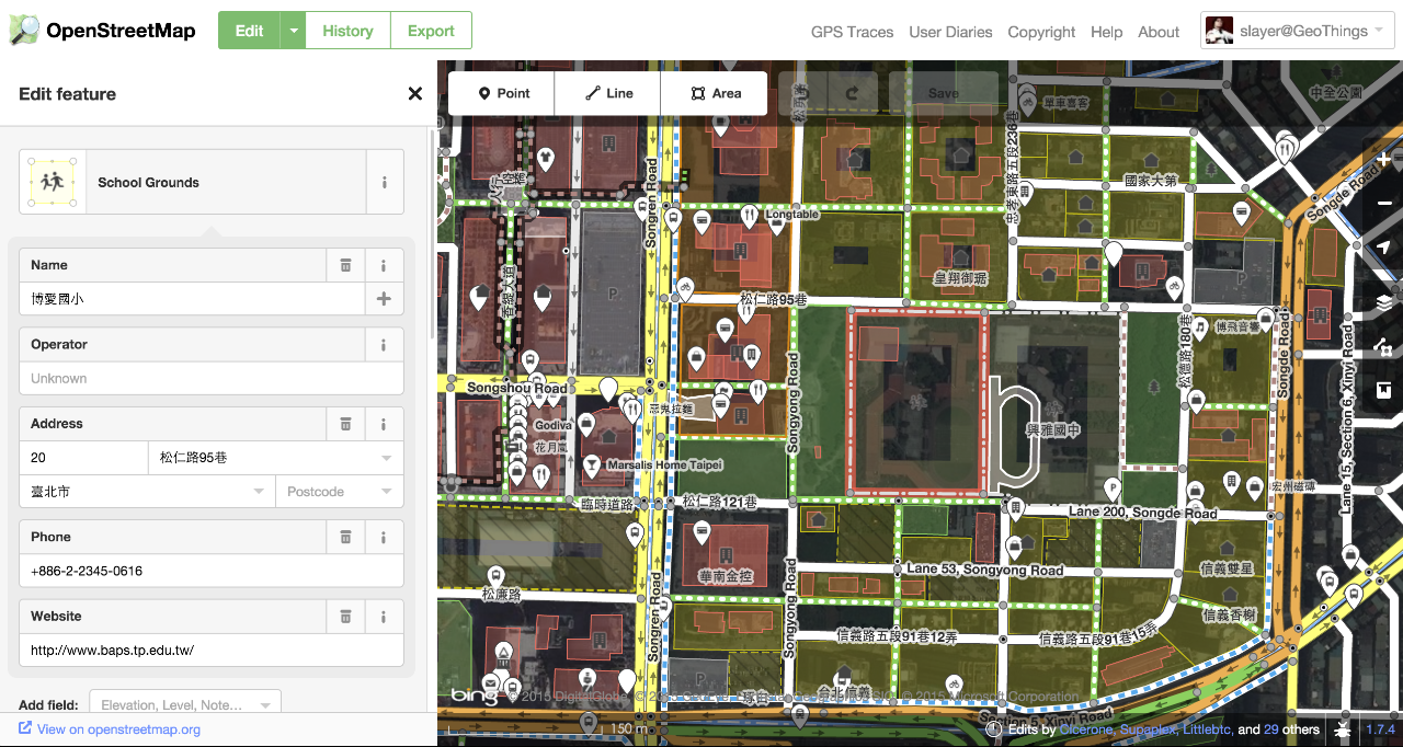
1. 地圖上看到博愛國小標示為「室內避難處所」
2. 查看左邊的避難處所說明資訊, 可以找到關於博愛國小的相關說明
3. 針對震災, 博愛國小是優先開設學校, 可容納 80 人, 同時有地址與電話
4. 在 OSM Editor 點選博愛國小 (如下圖)
> 需要先確定 tagging schema 才能一步步教學 :)
> [name=李昕迪]
1. 名稱是「博愛國小」沒有問題, 但 Amenity = School 的同時, 要如何加註這個地點是「台北市信義區安康里避難處所」?
2. 避難所種類: 戶外, 適用震災
3. 備註:容納 80 人
4. 電話: 02-2722-6616#601 (避難所開設後才能使用)
> 水保局有已經做好的土石流避難處所的資料,有GIS ShapeFile,也有json,[https://swcb.hackpad.com/DVKQx4ytzF6](https://swcb.hackpad.com/DVKQx4ytzF6),其他還有一些資料可以使用[http://246.swcb.gov.tw/OpenData.aspx](http://246.swcb.gov.tw/OpenData.aspx),不知道有沒有幫助?如果需要其他有關土石流避難的資料,水保局可以盡力提供。
> [name=Wen-Chun L]
> 請問 [http://246.swcb.gov.tw/preventInfo/RefugeMap.aspx](http://246.swcb.gov.tw/preventInfo/RefugeMap.aspx) 這樣的避難路線, 是否也有公開 KML 或是 GeoJSON 格式呢?
> [name=Kuo-Yu C]
> 目前只有避難處所的點位及KML(json有地址電話,ShapeFile及KML有位置),醫療處所的點位及KML,沒有避難路線的KML
> [name=Wen-Chun L]
> 土石流災害與避難路線資料有權威性的問題,而 OSM 定位在紀錄實際存在的地景,所以土石流災害與避難路線應該用途層疊上去而不要編輯到 OSM 上。
> [name=yellowsoar]
3.最後需要做資料驗證, 需要確認還有哪些區域沒有更新到, 以及針對已經更新到OSM的資料部分進行驗證跟維護工作.
## 2015/11 Geography Awareness Week
### 資料來源
- ncdr 避難收容處所開設情形 : [http://data.gov.tw/node/12849](http://data.gov.tw/node/12849)
> 這個是不是開設以後才會有資料? 沒記錯話是消防署那邊統一公告.
> [name=Kuo-Yu C]
> <shelterInfo adaptForWeaker="否" address="信義區松仁路95巷20號" county="臺北市" defaultville="安康里" disastertype="震災" isIndoor="是" isOutdoor="否" lat="25.0364" lon="121.5711"name="博愛國小" openstatus="撤除" peopleno="80" refugedno="" shelterCode="SA110-0001" shelterId="3162" town="信義區" twd97x="307630.45" twd97y="2769928.89371" village=" "/>
> [name=Chia-liang K]
> 一直都有,會有開設 openstatus="撤除"
> [name=Chia-liang K]
> 喔喔, 對, 馬上來看!! 不過還是得討論 OSM 上面的 tag 重複狀況怎樣解決. 村長的建議就直接解決了建立這些資料的功夫了!
> [name=Kuo-Yu C]
> 另外村長有看到 土石流避難路線 相關資訊嗎? 這邊圖之前看過, 超難懂.
> [name=Kuo-Yu C]
> 參考 [http://246.swcb.gov.tw/preventInfo/RefugeMap.aspx](http://246.swcb.gov.tw/preventInfo/RefugeMap.aspx)
> [name=Kuo-Yu C]
> [https://gist.github.com/mcdlee/049b4374d66c18241a5e](https://gist.github.com/mcdlee/049b4374d66c18241a5e) 轉成 .csv
> [name=李昕迪]
### Tagging schema 2015 edition
試著根據村長的說明來設計博愛國小的範例,請大家多多建議!! 配合原來的 tag, 後面 emergency 的延伸 tag 就是面臨災害時,這個建築物變成避難處所時的相關資訊。
addr:city=台北市
addr:district=信義區
addr:village=安康里
addr:full=110 臺北市信義區安康里松仁路95巷20號
addr:housenumber=20
addr:street=松仁路95巷
amenity=school
name=博愛國小
phone=+886 2 2345 0616 ext.400
> 用 [ITU-T E.123](http://www.wikiwand.com/en/E.123) and the [DIN 5008 標準](http://www.wikiwand.com/en/de:DIN_5008)
> [name=Supaplex]
postal_code=110
type=multipolygon
website=[http://www.baps.tp.edu.tw/](http://www.baps.tp.edu.tw/)
emergency:amenity=social_facility
emergency:social_facility=shelter
emergency:social_facility:id=3162
> 採用 shelterId
> [name=李昕迪]
emergency:social\_facility:for=displaced\_people
emergency:shelter_type=earthquake
> 要限制災害類型嗎
> [name=李昕迪]
> 目前災害類型根據圖資,有一下幾種,包括earthquake,floods,tsunami,debris flow.例子中的博愛國小是屬於地震避難所,所以標示earthquake.剛我也在想,如果是複合式避難所那要怎麼標示?用複選的方式嗎?還是多幾個column描述同一個地點的不同災害性質避難所,舉例來說,
> [name=Shih Y]
> emergency:shelter_type=earthquake
> [name=Kuo-Yu C]
> emergency:shelter_type=floods
> [name=Kuo-Yu C]
> emergency:shelter_type=debris flow
> [name=Kuo-Yu C]
> 可以用 分號
> [name=李昕迪]
> ex: emergency:shelter_type=earthquake;floods;debris flow
> [name=Supaplex]
emergency:operator=台北市政府消防局
emergency:social\_facility:opening\_hours=closed
emergency:social_facility:capacity=80
emergency:social_facility:phone=+886 2 2345 0616 ext. 400
emergency:social_facility:source=內政部消防署
emergency:contact:phone=+886 6638 0119
> 請問三個電話分別是哪些單位?
> [name=李昕迪]
> 原本的 phone 對應的就是這個 POI 平常的聯絡方式, 而 emergency:social_facility:phone 就是這個 POI 變成避難處所的聯絡電話 (一般以學校來說, 可能會對應不同的分機, 防災地圖會有標示), 再來 emergency:contact:phone 就是這個地區的緊急聯絡人 (已經公開在防災地圖上的資訊), 例如村里長, 或是學校的教務長之類人員.
> [name=Kuo-Yu C]
**使用 uMap 貢獻的方法**
首先, 找出你所屬或是您關心的村里防災地圖, 以工研院為例子, 則是 Google「竹東鎮 頭重里 防災地圖」, 我們最後在新竹縣政府消防局網頁找到相關資訊
[http://fire.hsinchu.gov.tw/evacuate/show.php?itemid=796&page=1](http://fire.hsinchu.gov.tw/evacuate/show.php?itemid=796&page=1)
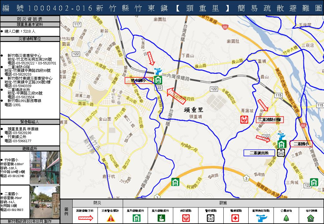
接著點選這個 uMap 網頁
[http://umap.openstreetmap.fr/zh-tw/map/map_60739](http://umap.openstreetmap.fr/zh-tw/map/map_60739)
然後按右上角的編輯 (一支筆的那個圖示), 會出現一排工具可以使用
可以利用左邊的搜尋工具, 找出你想編輯的地點
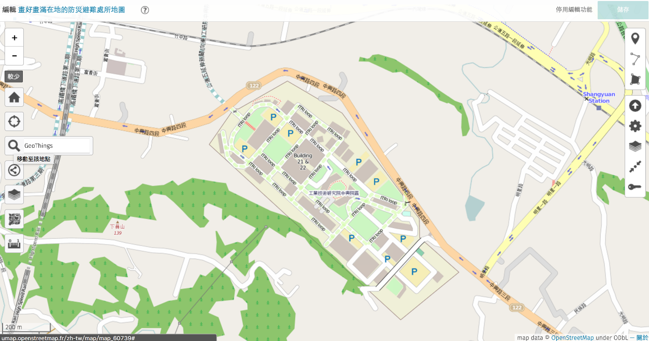
利用 uMap 右邊工具列的第一個功能, 根據 emergency 的 tag 建議來標示避難場所的位置
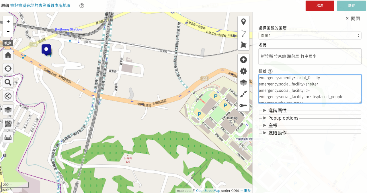
最後儲存, 就完成啦!!
## 20160325 大安森林公園避難演練:
因應 3/25 的防災演練, 打算要把這些維生配備位置圖, 用我們討論的 emergency tag 更新到 OSM 上. 在號稱可以收容四萬七千人的大安森林公園, 有以下設施, 大家可否建議該下怎樣的 tag 呢:
**大安森林公園維生配備設施:**
建議大安森林公園的避難露營區可以利用 emergency 的 prefix 來加入提供給 Refugee 的 camp_site 資訊
[http://wiki.openstreetmap.org/wiki/Tag:tourism%3Dcamp_site](http://wiki.openstreetmap.org/wiki/Tag:tourism%3Dcamp_site)
一、安置登記站:安置收容登錄處。
emergency:amenity=social_facility
emergency:social_facility=outreach/安置收容登錄處
emergency:operator=台北市政府
二、醫護站:受安置人員保健護理處。
emergency:amenity=social_facility
emergency:social\_facility=ambulatory\_care
emergency:operator=台北市政府
([http://wiki.openstreetmap.org/wiki/Proposed\_features/Healthcare\_2.0](http://wiki.openstreetmap.org/wiki/Proposed_features/Healthcare_2.0))
三、播音站:廣播系統設施放置位置。
(這邊標示播音站,如果是播音喇叭,又是架高的型態,可以使用man\_made=communications\_tower 這個標籤)
amenity=studio
studio=audio
四、物資管理站:防災公園開設時,放置維生物資(含社會局整備之6項物資存放區)空間。
(如果物資會在這邊發放,那可以考慮用 distribution)
emergency:amenity=social_facility;
emergency:social_facility=warehouse/distribution
emergency:operator=台北市政府社會局
五、器材倉庫:開設所需器材設備存放處。
emergency:amenity=social_facility
emergency:soclai_facility=warehouse
emergency:operator=台北市政府
六、指揮中心:防災公園開設時指揮應變、調度、處理中心。
(OSM 上找不到臨時開設的應變中心標籤啊 Orz)
emergency:office=government\_emergency\_operating_center
emergency:operator=台北市政府
七、設備配置圖及避難路線位置圖:防災公園內各項設施及緊急避難配置及位置圖。
(目前只有 tourism 這個 group 看起來比較合適,但應該要有 Refugee 這個 group 啊)
tourism=information
information=board
board_type=evacuation/emergency
八、伙食區:熱食烹煮或發送區。
emergency:amenity=social_facility
emergency:soclai\_facility=soup\_kitchen
emergency:operator=台北市政府
九、帳蓬區:帳篷搭設休憩區。
emergency:amenity=social_facility
emergency:soclai_facility=shelter/避災帳篷區
emergency:social_facility:for=migrant
emergency:operator=台北市政府
十、淋浴區:提供受安置人員淋浴空間。
(是否為災時開設? 這邊先假設平常就有這個淋浴空間)
amenity=shower
fee=no
wheelchair=yes/no (需要進一步確認)
十一、晒衣場:受安置人員換洗衣物曬衣區域。
amenity=wash_centre
loc_name=曬衣場
十二、公共廁所:公共廁所
amenity=toilets
access=yes
wheelchair=yes/no (可以進一步確認)
十三、垃圾場:安置產生之廢棄物集中處。
amenity=waste_disposal
十四、公共電話:公用電話。
amenity=telephone
十五、消防蓄水設施:消防用水取水池,防災公園內現有可抽水供消防救災用支池塘、噴水池。
emergency=fire\_water\_pond
十六、消防栓:消防栓。
emergency=fire_hydrant
fire_hydrant:type=pillar (這是在地上的那種, 如果是牆壁上的, type=wall)
十七、自來水取水站:維生用水取水位置。
amenity=water_point
十八、維生貯水槽:自來水維生貯水設施。
amenity=water_tank
十九、臨時廁所設置區:增設臨時廁所位置。
emergency:amenity=toilets
emergency:access=yes
**大安森林公園各項維生配備位置圖**
[http://dado.gov.taipei/ct.asp?xItem=1232311&CtNode=38404&mp=124021](http://dado.gov.taipei/ct.asp?xItem=1232311&CtNode=38404&mp=124021)

> 有數化檔案嗎?
> [name=Supaplex]
> 您說的數位化檔案是不是 Shape File 或是 KML 之類的圖層呢? 之前跟消防署那邊討論的時候得知, 台灣很多這樣的防災避災地圖都是用 GIS 系統匯出圖檔, 然後讓村里長使用 power point 格式繪製的, 因為 ppt 是大家都會使用的工具. 也因此很多村里在地防災地圖都是現在我們看到的圖檔.
> [name=Kuo-Yu C]
> 感覺要能快速導入OSM的話就需要數化檔案,像是shape geojson, KML 之類的檔案,稍微把tag放上就能上傳,像3/25要開設可能得先要來了
> [name=Supaplex]
## Reference
**關於在 OSM 註明防災地圖地區聯絡人的個資疑慮**
[http://geothings.tw/post/133436880745/osm-with-open-personal-info](http://geothings.tw/post/133436880745/osm-with-open-personal-info)
by Open Foundry 誠夏
**OpenHarzadMap Proposal**
[http://wiki.openstreetmap.org/wiki/OpenHazardMap](http://wiki.openstreetmap.org/wiki/OpenHazardMap)
**Tagging schema**
可參考 [http://wiki.openstreetmap.org/wiki/Humanitarian\_OSM\_Tags/HDM_preset](http://wiki.openstreetmap.org/wiki/Humanitarian_OSM_Tags/HDM_preset)
- 收容所/避難所
- [amenity](http://wiki.openstreetmap.org/wiki/Key:amenity)=[social_facility](http://wiki.openstreetmap.org/wiki/Tag:amenity%3Dsocial_facility)
- [social_facility](http://wiki.openstreetmap.org/wiki/Key:social_facility)=[shelter](http://wiki.openstreetmap.org/wiki/Tag:social_facility%3Dshelter)
> 和 amenity = shelter 是不是不一樣呢?
> [name=李昕迪]
> 承平時期如何和原有功能共存?是個問題。
> [name=李昕迪]
> 看起來只能選一個, 這應該會是問題, 有沒有機會使用「附功能」之類的 e.g. co_amenity? 全部都貼在 Note 好像也怪怪的.
> [name=Kuo-Yu C]
> 如果這些資料是和 eoc 那份 xml 一樣, osm 裏頭只要標註 reference id (==ref:tw:gov:shelter=SA110-0001==) 應該就可以了,再用特製的 renderer 抓資料一起畫出來即可;另一個選擇是建立 shelter code 對應 osm object 的 table
> [name=Chia-liang K]
> 帥! 這個 XML 是 TaipeiEOC 還是全省都有?
> [name=Kuo-Yu C]
> 我記得是 ncdr 共通的
> [name=Chia-liang K]
> 讚 解了大部分問題
> [name=李昕迪]
> 引入lifecycle概念,加前綴,但proposed:再加上:emergency,變成proposed:emergency:amenity=social_facilty
> [name=Supaplex]
> proposed:emergency:social_facility=shelter
> [name=Supaplex]
> 加上proposed 好像好長啊, 要不要就像 [**Kuang-che Wu**](https://www.facebook.com/kuangche.wu?fref=ufi) 提到的, 我們直接朝 de facto standard 目標來著手, 像是下列的想法, 是否適合呢?
> [name=Kuo-Yu C]
> emergency:amenity=social_facility
> [name=Kuo-Yu C]
> emergency:social_facility=shelter
> [name=Kuo-Yu C]
> emergency:shelter_id:tw= 3162
> [name=Kuo-Yu C]
> (可考慮使用 shelter_ref 較為直覺, 同時確認 UN OCHA 會不會有一套自己的編號)
> [name=Kuo-Yu C]
> emergency:shelter:disaster_type=earthquake, flood, tsunami
> [name=Kuo-Yu C]
> emergency:shelter:capacity=80
> [name=Kuo-Yu C]
> emergency:shelter: phone:tw=02-2222-2222
> [name=Kuo-Yu C]
> 以上討論需要收歛~~
> [name=李昕迪]
- [name](http://wiki.openstreetmap.org/wiki/Key:name)=…
> 和承平時期的名稱要不要區分?
> [name=李昕迪]
> 如果是大家熟悉的名字, 例如OO國小, 應該就都用同樣的名字即可. 不然有可能大家緊急的時候找不到(或沒聯想到)這兩個名字是同一個地方
> [name=Kuo-Yu C]
> 也可以不寫,或是用emergency:name=xxx來表示啟用時災防單位用的名稱
> [name=Supaplex]
> 是否需要加上 emergency:shelter:name=xxx 這樣呢?
> [name=Kuo-Yu C]
- [operator](http://wiki.openstreetmap.org/wiki/Key:operator)=…
- [social_facility:for](http://wiki.openstreetmap.org/wiki/Key:social_facility:for) = (為誰設立, 這邊可以考慮使用 disaster_displacement)
- [opening_hours](http://wiki.openstreetmap.org/wiki/Key:opening_hours)=Mo-Fr 08:30-20:00,Tu-Su 08:00-15:00; Sa 08:00-12:00
> 這個應該就只有「因應緊急狀況而開設」才會有, 所以 opening_hours 好像不用說明
> [name=Kuo-Yu C]
> 這個應該要提 proposal [http://wiki.openstreetmap.org/wiki/Proposal_process](http://wiki.openstreetmap.org/wiki/Proposal_process)
> [name=yellowsoar]
- [source](http://wiki.openstreetmap.org/wiki/Key:source)=…
- [note](http://wiki.openstreetmap.org/wiki/Key:note)=…
- [capacity](https://wiki.openstreetmap.org/wiki/Key:capacity)=容納人數
- [shelter](https://wiki.openstreetmap.org/wiki/Key:shelter)=yes/no
> 這個 shelter 很奇妙的是講巴士站有沒有遮雨棚, 我們能不能延伸用在不同建築物上啊 XD
> [name=Kuo-Yu C]
**Humanitarian OSM Tags/HDM preset:**
[http://wiki.openstreetmap.org/wiki/Humanitarian\_OSM\_Tags/HDM_preset#Hazards](http://wiki.openstreetmap.org/wiki/Humanitarian_OSM_Tags/HDM_preset#Hazards)
**_examples of shelter according to the HOT OSM Tags_** **preset**
**Shelter**
[amenity](http://wiki.openstreetmap.org/wiki/Key:amenity)=[social_facility](http://wiki.openstreetmap.org/wiki/Tag:amenity%3Dsocial_facility)
[social_facility](http://wiki.openstreetmap.org/wiki/Key:social_facility)=[shelter](http://wiki.openstreetmap.org/wiki/Tag:social_facility%3Dshelter)
[name](http://wiki.openstreetmap.org/wiki/Key:name)=…
[operator](http://wiki.openstreetmap.org/wiki/Key:operator)=…
[social_facility:for](http://wiki.openstreetmap.org/wiki/Key:social_facility:for)=abused,child,disabled person,diseased,drug\_addicted,homeless,juvenile,mental\_health,migrant,orphan,senior,underprivileged,victim
[opening_hours](http://wiki.openstreetmap.org/wiki/Key:opening_hours)=Mo-Fr 08:30-20:00,Tu-Su 08:00-15:00; Sa 08:00-12:00
[source](http://wiki.openstreetmap.org/wiki/Key:source)=…
[note](http://wiki.openstreetmap.org/wiki/Key:note)=…
**Proposed features/Muster point**
國外有人丟出muster point的proposal tagging schema,也就是說, shelter在OSM上面是代表涼亭的意思,並不是我們所謂的避難所. 反而像是meetup point或是muster point才是所謂的災害發生時所謂的集合點.更貼切的還有refugee camp.
_Muster Point_
[http://wiki.openstreetmap.org/wiki/Proposed\_features/Muster\_point](http://wiki.openstreetmap.org/wiki/Proposed_features/Muster_point)
_Refugee Camp Mapping tagging schema_
[http://wiki.openstreetmap.org/wiki/Refugee\_Camp\_Mapping](http://wiki.openstreetmap.org/wiki/Refugee_Camp_Mapping)
> Muster Point 感覺是會合點, Shelter 還分室內室外還有沒有資源等等. 而 Refugee Camp 與我們目前要做的 shelter mapping 意義上似乎有不小差距. 因應敘利亞難民而建立的避難營區, 跟我們平常小學生上課, 發生災害時轉換成避難場所, 這個用法或許要再討論..
> [name=Kuo-Yu C]
> _A Quick Mailing list to discuss the tags used in OSM, how they could evolve, and how editors and renderers might interact with them._
> [name=Shih Y]
> _You may want to propose a new tag on_ [_http://wiki.openstreetmap.org/wiki/Proposed_features_](http://wiki.openstreetmap.org/wiki/Proposed_features) _and combine this with a quick email to the OSM tagging mailing list to see if anyone has already started this._ [_http://lists.openstreetmap.org/listinfo/tagging_](http://lists.openstreetmap.org/listinfo/tagging)
> [name=Shih Y]
**Proposal Page Template:**
> 沒寫過 OSM Proposal, 各位可以一起看看嗎?
> [name=Kuo-Yu C]
> 我先幫各位把可能的部分寫下來(我也沒寫過OSM Proposal), 再麻煩大家來找碴, 幫忙訂正修改, 感謝!
> [name=Shih Y]
> Please follow the instruction, and help to create the proposal:
> [name=Shih Y]
> [http://wiki.openstreetmap.org/wiki/Proposal_process](http://wiki.openstreetmap.org/wiki/Proposal_process)
> [name=Shih Y]
```
{{Proposal_Page
|name = Proposed to have co_amenity
|user = People in Taiwan and the rest of the world with such co_amenity issue in their living countries
|key =
|value = High
|type =
|definition = Proposed to have co_amenity for emergency time
|appearance = List of Taggings
|status =
|draftStartDate =
|rfcStartDate =
|voteStartDate =
|voteEndDate =
}}
== Proposal ==
Propose to have co_amenity
== Rationale ==
Due to some buildings or area (e.g. school, park) can be emergency shelter during disaster, we propose that amenity can have an alternative attribute to describe its function.
== Examples ==
amenity=school
co_amenity=shelter
== Tagging ==
The Proposed Emergency Tagging Schema: (with 15 characters limitation)
emergency:amenity=social_facility
emergency:social_facility=shelter;soup kitchen
emergency:social_facility:id=3162
emergency:shelter_type=earthquake;floods;debris flow
emergency:operator=台北市政府消防局
emergency:social\_facility:opening\_hours=closed;24/7
emergency:social_facility:capacity=80
emergency:social_facility:phone=+886-2-2345-0616p400
emergency:social_facility:source=內政部消防署
emergency:contact:phone=+886-6638-0119
== Applies to ==
areas
== Rendering ==
== Features/Pages affected ==
== Comments ==
Please comment on the [[{{TALKPAGENAME}}|discussion page]].
```
## 其他
防空警報避難空間
低溫收容所
 Sign in with Wallet
Connect another wallet
Sign in with Wallet
Connect another wallet