# <font color="orange" size="76">2024陽明交大OpenStreetMap介紹</font>
<!-- Put the link to this slide here so people can follow -->
<font color="#000000">slide: [https://hackmd.io/@osm-tw/HJJqv7HC6](https://hackmd.io/@osm-tw/HJJqv7HC6)</font>
<!-- .slide: data-background="https://i.imgur.com/zIpva9R.jpg" -->
CC-BY-4.0 OpenStreetMap Taiwan Community
2024/05/23 台灣開放街圖社群 陳瑞霖
Note:
Ta̍k-ke hó, Hello everyone, This is Dennis Raylin Chen from Taiwan, I want to talk about cleaning and managing dataset. My speech's title is "Linking OpenStreetmap and Wikidata: Case study of Taiwan's villages and rivers datasets"
---
## 我是誰?
- [Supaplex](https://www.openstreetmap.org/user/Supaplex)
- [OpenStreetMap](https://www.openstreetmap.org) :heart: [Wikidata](https://www.wikidata.org) :heart:
- [Wikimedia Taiwan](https://meta.wikimedia.org/wiki/Wikimedia_Taiwan/zh) :cat:
---
## 首先
* 註冊 https://www.openstreetmap.org 帳號
* 連結 OSM 帳號到 [HOT Tasking Manager](https://tasks.hotosm.org/projects/16316)
---
## 為什麼要關注 OpenStreetMap
* 受維基百科啟發,維基式產生地理資料
* OpenStreetMap 是跨語言的地理資料庫
* 允許國際化語言,也有在地化語言
* 能索引其他資料庫的資料,例如:Wikidata
* OpenStreetMap 有經緯度資訊,也能存放地理資料本身的結構化資料
---
## OpenStreetMap
* https://www.openstreetmap.org
* 縮網址:osm.org
* 華語:開放街圖
* Tâi-gír: khai-hòng Kue-tôo
---
## OSM 簡介
* 2004成立,後來以英國NGO型式管理大家共編圖資
* 社群共編的網路地圖
* 維基百科版本的地圖
* 使用OSM的服務:Pokemon Go、Wikimedia、 Apple Photo、Facebook、實價登錄網站、台北市土壤潛勢地圖
---
## 創辦人
<div style="background-color: blue;
color: white;
padding: 10px;
border: solid 3px #0F7391;
margin: 10px;">
* 英國人 [Steve Coast](https://en.wikipedia.org/wiki/Steve_Coast)
* GIS 領域學生
* 當年英國OS Geodata太貴了
* 受到維基百科影響,決定創辦類似的地圖計畫,讓所有人都能貢獻圖資
* 勤跑各大Linux大會推廣
</div>
---
## 理念
<!-- Kagami CC-BY-NC-SA https://www.slideshare.net/ShiXunHong/the-workshop-of-opensstreetmap-on-11102017-in-punplace -->
開放街圖的三大特色
```mermaid
%%{init: {'theme':'forest'}}%%
graph LR;
1((開源 Open Source))---2((開放 Open Data))---3((協作 Collaboration))---1;
```
---
## 硬體架構
<div style="background-color:#ccc">

</div>
---
## 開源 Open Source
<!--slide mode css -->
<div style="display:inline-flex;align-items:center;gap:1rem;">
<div style="font-size:75%;flex:1;text-align:left" left>
相關專案皆以軟體開源授權釋出
* 地圖編輯器 (iD、 JOSM)
* 地圖顯示器 (Mapnik 、 Leaflet)
資料伺服器使用開源軟體
* Linux
* PostgreSQL
</div>
<div style="height:75%" right>
>
><span style="font-size:50%">(iD)</span>

><span style="font-size:50%">JOSM</span>
</div>
</div>
---
## 開放 Open Data
* 原始資料
* [ODbL 授權](https://opendatacommons.org/licenses/odbl/)
* 地圖顯示圖檔、相關文件
* [創用CC授權 – CC BY-SA](https://creativecommons.org/licenses/by-sa/2.0)
<span style="margin-left:2rem;filter:invert(100%)"></span>
---
## 協作 Collaboration
<div style="display:inline-flex;align-items:center;gap:2rem;">
<div style="font-size:90%;flex:1;text-align:left" left>
* 共同編輯
* Wikipedia
* 社群導向
* 地圖巡守、除錯
* 自我組織化,例:[OpenStreetMap US](https://openstreetmap.us), [HOT](https://www.hotosm.org/), [OpenStreetMap台灣](https://osm.tw/)
</div>
<div>
<span style="margin-left:2rem;filter:invert(100%)"></span>
</div>
</div>
---
## 資料格式
<!--slide mode css -->
<div style="display:inline-flex;align-items:center;gap:2rem;">
<div style="font-size:75%" left>

</div>
<div style="flex:1;text-align:left" right>
* 點 (node):
實際帶有經緯度資訊的部分
* 線 (line)、區域 (area):
線段或構成封閉區域
* 關聯 (relation):
多個線段或點的集合,可構成公車路線、行政邊界、溪流流域
</div>
</div>
---
## 原始資料

---
## 範例 [OSM-Carto](https://www.openstreetmap.org/#map=16/22.9958/120.2193)-國立成功大學
<div style="display:inline-flex;align-items:left;">
<div left>

</div>
<div style="font-size:85%;display:flex;background-color:rgb(127 195 140/0.5);padding:1px;justify-content:flex-end;">
<div style="flex-direction:column; text-align:left">
* amenity=university
* name=國立成功大學
* wikipedia=[zh:國立成功大學](https://zh.wikipedia.org/wiki/國立成功大學)
* wikidata=[Q706708](https://www.wikidata.org/wiki/Q706708)
</div>
</div>
</div>
---
## 範例 OSM-Cyclo-國立成功大學
<div style="display:inline-flex;align-items:left;">
<div left>

</div>
<div style="font-size:85%;display:flex;background-color:rgb(127 195 140/0.5);padding:1px;justify-content:flex-end;">
<div style="flex-direction:column; text-align:left">
* amenity=university
* name=國立成功大學
* wikipedia=[zh:國立成功大學](https://zh.wikipedia.org/wiki/國立成功大學)
* wikidata=[Q706708](https://www.wikidata.org/wiki/Q706708)
</div>
</div>
</div>
---
## 範例 OSM-Public Transport Map-國立成功大學
<div style="display:inline-flex;align-items:left;">
<div left>

</div>
<div style="font-size:85%;display:flex;background-color:rgb(127 195 140/0.5);padding:1px;justify-content:flex-end;">
<div style="flex-direction:column; text-align:left">
* amenity=university
* name=國立成功大學
* wikipedia=[zh:國立成功大學](https://zh.wikipedia.org/wiki/國立成功大學)
* wikidata=[Q706708](https://www.wikidata.org/wiki/Q706708)
</div>
</div>
</div>
---
## 使用情境 - 救災快速反應
<div style="display:inline-flex;align-items:center;gap:1rem;">
<div style="font-size:75%;flex:1;text-align:left" left>
* 災難後快速繪製地圖 [Humanitarian OpenStreetMap Team](https://www.hotosm.org/)
* 2010年海地地震
* 2010年10月成為美國NGO組織
* 2013年 [Tasking Manager](http://tasks.hotosm.org/) 推出
* 2013年海燕颱風、2015年尼泊爾大地震、2023年土耳其-敘利亞大地震
</div>
<div style="height:75%" right>

</div>
</div>
---
## 海地地震
{%youtube oNZ_ZBCTRqc %}
---
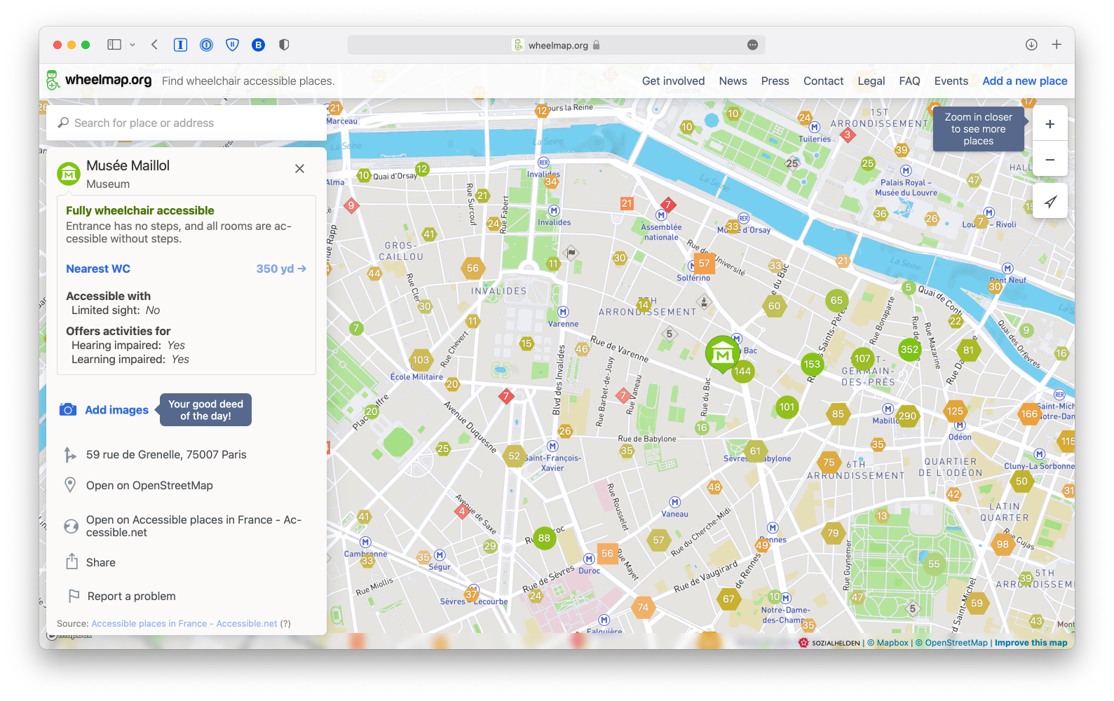
## 無障礙環境地圖
[wheelmap.org](https://wheelmap.org/nodes/3799089099)
---
## OpenStreetMap 在台灣的長處
<div style="display:inline-flex;align-items:center;gap:2rem;">
<div style="flex:1;text-align:left;font-size:100%;" left>
* 高壓電塔
* 登山路線
* 墓仔埔
* 跨資料庫:OpenStreetMap、Wikidata、Wikipedia
</div>
<div style="flex:1;text-align:left;font-size:100%;" left>
* 多語言:
* 臺灣閩南語/臺灣台語/臺灣話/Tai-gir/Hokien
* Ha̍k-ka-fa/台灣客語/客家話
* 台灣南島民族語言/台灣原住民語言
</div>
</div>
Note:
相比其他商業地圖,OpenStreetMap 佇臺灣注重野外會當看著的物件,親像講高壓電塔、𬦰山路線,嘛有真濟墓仔埔。OpenStreetMap 是網路地圖,所以會當簡單連結線頂資源,親像 Wikidata 佮 Wikipedia。濟語言的嘛是加添臺灣的臺灣台語、臺灣 Hak-ka-fa、種種臺灣原住民語言攏會用得。當然外國人講的英文佮日語嘛是簡單加入。
---
## 魯地圖

---
## <center>高壓電線與變電所</center>
<!--slide mode css -->
<div style="display:inline-flex;gap:1rem;">
<div style="flex:1;font-size:100%;text-align:left:min-width:50%" left>
* 高壓電線與變電所
* http://overpass-turbo.eu/s/kpv
</div>
<div right>

</div>
</div>
---
## OSM 村里視覺化
[](https://overpass-turbo.eu/s/1kR3)
Note:
七千偌接近八千个村里佇咧 OpenStreetMap 的視覺化
---
## 示範時間
https://www.openstreetmap.org
[台南一帶便利商店](https://resultmaps.neis-one.org/osm-notes-country?c=Taiwan&limit=no)
---
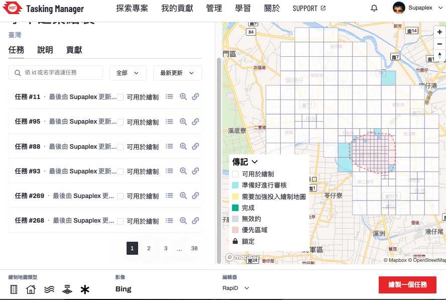
## 示範時間 2
HOT Tasking Manager: https://tasks.hotosm.org/projects/16316/
---
## 方法-描圖
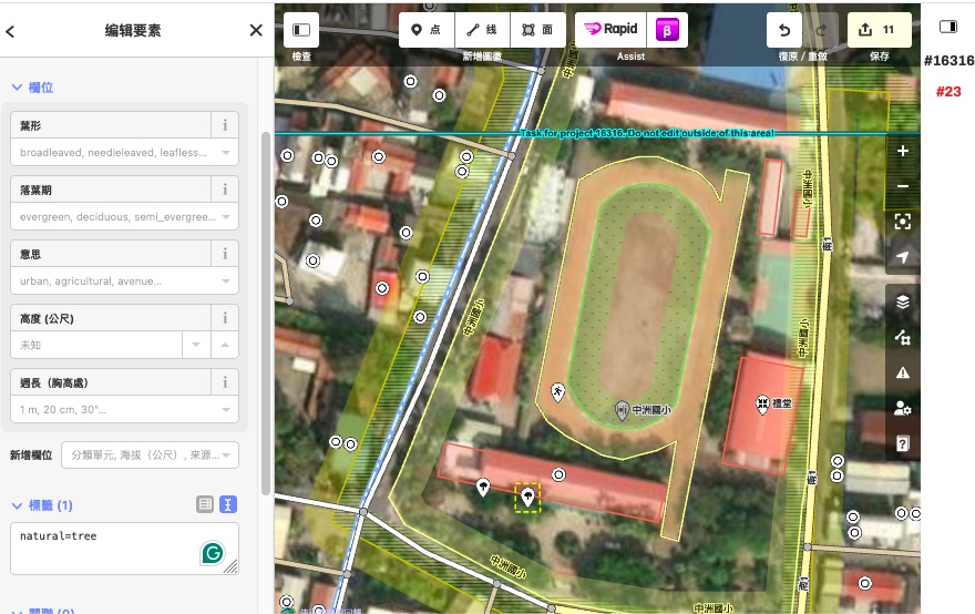
---
## HOT Tasking Manager 協調共同繪製地圖
---
## 來動手增進台灣圖資數量與品質吧!
---
## OSM x Wikidata 月聚
* 4/1 19:30 @摩茲工寮
* Facebook [OpenStreetMap台灣](https://www.facebook.com/groups/OpenStreetMap.TW/)

---
## [To-siā!](https://en.wiktionary.org/wiki/%E5%A4%9A%E8%AC%9D#Chinese) [sṳ̀n-mùng-ǹ!](https://en.wiktionary.org/wiki/%E6%89%BF%E8%92%99%E4%BD%A0) Thank you! :sheep:
你可以在以下管道找到我
<div style="display:inline-flex;align-items:center;gap:2rem;">
<div style="flex:1;text-align:left" left>
- [GitHub](https://github.com/Supaplextw/)
- Supaplex: [Wikidata](https://wikidata.org/wiki/User:Supaplex),[OpenStreetMap](https://www.openstreetmap.org/user/Supaplex)
- 或是寄[電子郵件](mailto:dennis@wikimedia.tw)
</div>
<div style="flex:1;text-align:left" left>
* 臉書社團 Wikidata Taiwan
* 臉書社團 OpenStreetMap台灣
* OSM Wiki [Taiwan](https://wiki.openstreetmap.org/wiki/Taiwan)
</div>
</div>
{"description":"View the slide with \"Slide Mode\".","title":"2024成大OpenStreetMap Workshop","contributors":"[{\"id\":\"6d29f5f5-3da6-40f2-b920-e9a4cc2181dd\",\"add\":12495,\"del\":3466}]"}