<div style="display:flex; flex-direction:column;">
<div>
<!-- .slide: data-background="https://i.imgur.com/zIpva9R.jpg" data-background-opacity="0.6"-->
</div>
<div style="font-size:55%;padding:32px">
# <font color="white">離線圖資 Openstreetmap 的防災應用以及 OSINT 淺談</font>
</div>
 
<div style="font-size:35px;display:flex;background-color:rgb(157 195 145/0.5);padding:32px;justify-content:flex-end;">
<div style="flex-direction:column; text-align:left">
<font color="#000000">
<div>slide: https://hackmd.io/@osm-tw/HkWWUOS_Xd</div>
<div>CC-BY-4.0 OpenStreetMap Taiwan Community</div>
<div>OpenStreetMap Taiwan 陳瑞霖, 2025/11/02</div>
</font>
</div>
</div>
</div>
---
## 我是誰?
<!-- .slide: data-background="https://upload.wikimedia.org/wikipedia/commons/thumb/d/d1/Wikimedia_Maps_Pehoeji_label.png/1024px-Wikimedia_Maps_Pehoeji_label.png" data-background-opacity="0.5"-->
- [Supaplex](https://www.openstreetmap.org/user/Supaplex)
- [OpenStreetMap](https://www.openstreetmap.org) :heart: [Wikidata](https://www.wikidata.org) :heart:
- [Wikimedia Taiwan](https://meta.wikimedia.org/wiki/Wikimedia_Taiwan/zh) :cat:
---
## 大綱
<!-- .slide: data-background="https://upload.wikimedia.org/wikipedia/commons/thumb/8/86/OpenStreetMap_homepage_2022_en.png/640px-OpenStreetMap_homepage_2022_en.png" data-background-opacity="0.5"-->
<div style="display:inline-flex;align-items:center;gap:2rem;background-color: rgb(0 0 0 / 0.5);">
<div style="flex:1;text-align:left;font-size:100%;" left>
* OpenStreetMap簡介
* 常見 App 與登山應用
* 各地的社群生態
* OpenStreetMap與姐妹計劃
</div>
<div style="flex:1;text-align:left;font-size:80%;" left>
* OpenStreetMap在台灣的發展
* 展示時段
* 結語:多認識實踐體驗
</div>
</div>
---
## 為什麼要關注 OpenStreetMap
<!-- .slide: data-background="https://upload.wikimedia.org/wikipedia/commons/thumb/d/d1/Wikimedia_Maps_Pehoeji_label.png/1024px-Wikimedia_Maps_Pehoeji_label.png" data-background-opacity="0.5"-->
* 受維基百科啟發,維基式產生地理資料
* OpenStreetMap 是跨語言的地理資料庫
* 允許國際化語言,也有在地化語言
* 能索引其他資料庫的資料,例如:Wikidata
* OpenStreetMap 有經緯度資訊,也能存放地理資料本身的結構化資料
---
## Open Data 浩劫
<!-- .slide: data-background="https://upload.wikimedia.org/wikipedia/commons/thumb/8/86/OpenStreetMap_homepage_2022_en.png/640px-OpenStreetMap_homepage_2022_en.png" data-background-opacity="0.5"-->
<!-- Kagami CC-BY-NC-SA https://www.slideshare.net/ShiXunHong/the-workshop-of-opensstreetmap-on-11102017-in-punplace -->
[](https://en.wikipedia.org/wiki/2025_United_States_government_online_resource_removals)
Note:
美國總統川普上台之後,因為對一些如全球暖化還有性別相關有不同意見,導致美國政府大量資料被移除。這讓我們思考除了仰賴政府,是否也要自行架設。
---
## OpenStreetMap
<!-- .slide: data-background="https://upload.wikimedia.org/wikipedia/commons/thumb/d/d1/Wikimedia_Maps_Pehoeji_label.png/1024px-Wikimedia_Maps_Pehoeji_label.png" data-background-opacity="0.5"-->
* https://www.openstreetmap.org
* 縮網址:osm.org
* 華語:開放街圖
* Tâi-gír: khai-hòng Kue-tôo
---
## OSM 簡介
<!-- .slide: data-background="https://upload.wikimedia.org/wikipedia/commons/thumb/8/86/OpenStreetMap_homepage_2022_en.png/640px-OpenStreetMap_homepage_2022_en.png" data-background-opacity="0.5"-->
<!-- Kagami CC-BY-NC-SA https://www.slideshare.net/ShiXunHong/the-workshop-of-opensstreetmap-on-11102017-in-punplace -->
* 2004成立,後來以英國NGO型式管理大家共編圖資
* 社群共編的網路地圖
* 維基百科版本的地圖
* 使用OSM的服務:Pokemon Go、Wikimedia、 Apple Photo、Facebook、實價登錄網站、台北市土壤潛勢地圖
---
## 創辦人
<!-- .slide: data-background="https://upload.wikimedia.org/wikipedia/commons/thumb/8/86/OpenStreetMap_homepage_2022_en.png/640px-OpenStreetMap_homepage_2022_en.png" data-background-opacity="0.5"-->
<!-- Kagami CC-BY-NC-SA https://www.slideshare.net/ShiXunHong/the-workshop-of-opensstreetmap-on-11102017-in-punplace -->
<div style="background-color: blue;
color: white;
padding: 10px;
border: solid 3px #0F7391;
margin: 10px;">
* 英國人 [Steve Coast](https://en.wikipedia.org/wiki/Steve_Coast)
* GIS 領域學生
* 當年英國OS Geodata太貴了
* 受到維基百科影響,決定創辦類似的地圖計畫,讓所有人都能貢獻圖資
* 勤跑各大Linux大會推廣
</div>
---
## 理念
<!-- .slide: data-background="https://upload.wikimedia.org/wikipedia/commons/thumb/8/86/OpenStreetMap_homepage_2022_en.png/640px-OpenStreetMap_homepage_2022_en.png" data-background-opacity="0.5"-->
<!-- Kagami CC-BY-NC-SA https://www.slideshare.net/ShiXunHong/the-workshop-of-opensstreetmap-on-11102017-in-punplace -->
開放街圖的三大特色
```mermaid
%%{init: {'theme':'forest'}}%%
graph LR;
1((開源 Open Source))-------2((開放 Open Data))-------3((協作 Collaboration))-------1;
```
---
## 硬體架構
<!-- .slide: data-background="https://upload.wikimedia.org/wikipedia/commons/thumb/8/86/OpenStreetMap_homepage_2022_en.png/640px-OpenStreetMap_homepage_2022_en.png" data-background-opacity="0.5"-->
<!-- Kagami CC-BY-NC-SA https://www.slideshare.net/ShiXunHong/the-workshop-of-opensstreetmap-on-11102017-in-punplace -->
<div style="background-color:#ccc">

</div>
---
## 開源 Open Source
<!-- .slide: data-background="https://upload.wikimedia.org/wikipedia/commons/thumb/8/86/OpenStreetMap_homepage_2022_en.png/640px-OpenStreetMap_homepage_2022_en.png" data-background-opacity="0.5"-->
<!-- Kagami CC-BY-NC-SA https://www.slideshare.net/ShiXunHong/the-workshop-of-opensstreetmap-on-11102017-in-punplace -->
<!--slide mode css -->
<div style="display:inline-flex;align-items:center;gap:1rem;">
<div style="font-size:75%;flex:1;text-align:left" left>
相關專案皆以軟體開源授權釋出
* 地圖編輯器 (iD、 JOSM)
* 地圖顯示器 (Mapnik 、 Leaflet)
資料伺服器使用開源軟體
* Linux
* PostgreSQL
</div>
<div style="height:75%" right>
>
><span style="font-size:50%">(iD)</span>

><span style="font-size:50%">JOSM</span>
</div>
</div>
---
## 開放 Open Data
<!-- .slide: data-background="https://upload.wikimedia.org/wikipedia/commons/thumb/8/86/OpenStreetMap_homepage_2022_en.png/640px-OpenStreetMap_homepage_2022_en.png" data-background-opacity="0.5"-->
<!-- Kagami CC-BY-NC-SA https://www.slideshare.net/ShiXunHong/the-workshop-of-opensstreetmap-on-11102017-in-punplace -->
* 原始資料
* [ODbL 授權](https://opendatacommons.org/licenses/odbl/)
* 地圖顯示圖檔、相關文件
* [創用CC授權 – CC BY-SA](https://creativecommons.org/licenses/by-sa/2.0)
<span style="margin-left:2rem;filter:invert(100%)"></span>
---
## 協作 Collaboration
<!-- .slide: data-background="https://upload.wikimedia.org/wikipedia/commons/thumb/8/86/OpenStreetMap_homepage_2022_en.png/640px-OpenStreetMap_homepage_2022_en.png" data-background-opacity="0.5"-->
<!-- Kagami CC-BY-NC-SA https://www.slideshare.net/ShiXunHong/the-workshop-of-opensstreetmap-on-11102017-in-punplace -->
<div style="display:inline-flex;align-items:center;gap:2rem;">
<div style="font-size:90%;flex:1;text-align:left" left>
* 共同編輯
* Wikipedia
* 社群導向
* 地圖巡守、除錯
* 自我組織化,例:[OpenStreetMap US](https://openstreetmap.us), [HOT](https://www.hotosm.org/), [OpenStreetMap台灣](https://osm.tw/)
</div>
<div>
<span style="margin-left:2rem;filter:invert(100%)"></span>
</div>
</div>
---
## 資料格式
<!-- .slide: data-background="https://upload.wikimedia.org/wikipedia/commons/thumb/8/86/OpenStreetMap_homepage_2022_en.png/640px-OpenStreetMap_homepage_2022_en.png" data-background-opacity="0.5"-->
<!-- Kagami CC-BY-NC-SA https://www.slideshare.net/ShiXunHong/the-workshop-of-opensstreetmap-on-11102017-in-punplace -->
<!--slide mode css -->
<div style="display:inline-flex;align-items:center;gap:2rem;">
<div style="font-size:75%" left>

</div>
<div style="flex:1;text-align:left" right>
* 點 (node):
實際帶有經緯度資訊的部分
* 線 (line)、區域 (area):
線段或構成封閉區域
* 關聯 (relation):
多個線段或點的集合,可構成公車路線、行政邊界、溪流流域
</div>
</div>
---
## 原始資料
<!-- .slide: data-background="https://upload.wikimedia.org/wikipedia/commons/thumb/8/86/OpenStreetMap_homepage_2022_en.png/640px-OpenStreetMap_homepage_2022_en.png" data-background-opacity="0.5"-->
<!-- Kagami CC-BY-NC-SA https://www.slideshare.net/ShiXunHong/the-workshop-of-opensstreetmap-on-11102017-in-punplace -->

---
## 範例 [OSM-Carto](https://www.openstreetmap.org/#map=18/24.95354/121.22572)-中壢
<!-- .slide: data-background="https://upload.wikimedia.org/wikipedia/commons/thumb/8/86/OpenStreetMap_homepage_2022_en.png/640px-OpenStreetMap_homepage_2022_en.png" data-background-opacity="0.5"-->
<!-- Kagami CC-BY-NC-SA https://www.slideshare.net/ShiXunHong/the-workshop-of-opensstreetmap-on-11102017-in-punplace -->
<div style="display:inline-flex;align-items:left;">
<div left>

</div>
<div style="font-size:85%;display:flex;background-color:rgb(127 195 140/0.5);padding:1px;justify-content:flex-end;">
<div style="flex-direction:column; text-align:left">
* railway=station
* name=中壢
* wikipedia=[zh:中壢車站](https://zh.wikipedia.org/wiki/中壢車站)
* wikidata=[Q8070944](https://www.wikidata.org/wiki/Q8070944)
</div>
</div>
</div>
---
## 範例 OSM-transport-中壢
<!-- .slide: data-background="https://upload.wikimedia.org/wikipedia/commons/thumb/8/86/OpenStreetMap_homepage_2022_en.png/640px-OpenStreetMap_homepage_2022_en.png" data-background-opacity="0.5"-->
<!-- Kagami CC-BY-NC-SA https://www.slideshare.net/ShiXunHong/the-workshop-of-opensstreetmap-on-11102017-in-punplace -->
<div style="display:inline-flex;align-items:left;">
<div left>

</div>
<div style="font-size:85%;display:flex;background-color:rgb(127 195 140/0.5);padding:1px;justify-content:flex-end;">
<div style="flex-direction:column; text-align:left">
* railway=station
* name=中壢
* wikipedia=[zh:中壢車站](https://zh.wikipedia.org/wiki/中壢車站)
* wikidata=[Q8070944](https://www.wikidata.org/wiki/Q8070944)
</div>
</div>
</div>
---
## 使用情境 - 救災快速反應
<!-- .slide: data-background="https://upload.wikimedia.org/wikipedia/commons/thumb/8/86/OpenStreetMap_homepage_2022_en.png/640px-OpenStreetMap_homepage_2022_en.png" data-background-opacity="0.5"-->
<!-- Kagami CC-BY-NC-SA https://www.slideshare.net/ShiXunHong/the-workshop-of-opensstreetmap-on-11102017-in-punplace -->
<div style="display:inline-flex;align-items:center;gap:1rem;">
<div style="font-size:65%;flex:1;text-align:left" left>
* 災難後快速繪製地圖 [Humanitarian OpenStreetMap Team](https://www.hotosm.org/)
* 2010年海地地震
* 2010年10月成為美國NGO組織
* 2013年 [Tasking Manager](http://tasks.hotosm.org/) 推出
* 2013年海燕颱風、2015年尼泊爾大地震、2023年土耳其-敘利亞大地震
</div>
<div style="height:75%" right>

</div>
</div>
---
## 海地地震
<!-- .slide: doata-background="https://upload.wikimedia.org/wikipedia/commons/thumb/8/86/OpenStreetMap_homepage_2022_en.png/640px-OpenStreetMap_homepage_2022_en.png" data-background-opacity="0.5"-->
{%youtube BwMM_vsA3aY %}
---
## 無障礙環境地圖
<!-- .slide: data-background="https://upload.wikimedia.org/wikipedia/commons/thumb/8/86/OpenStreetMap_homepage_2022_en.png/640px-OpenStreetMap_homepage_2022_en.png" data-background-opacity="0.5"-->
<!-- Kagami CC-BY-NC-SA https://www.slideshare.net/ShiXunHong/the-workshop-of-opensstreetmap-on-11102017-in-punplace -->
[wheelmap.org](https://wheelmap.org/nodes/3799089099)

---
## 週邊計劃
<!-- .slide: data-background="https://upload.wikimedia.org/wikipedia/commons/thumb/8/86/OpenStreetMap_homepage_2022_en.png/640px-OpenStreetMap_homepage_2022_en.png" data-background-opacity="0.5"-->
<div style="display:inline-flex;align-items:center;gap:4rem;">
<div>
* [Nominatim](https://nominatim.org/) - Geocoding
* [OSRM](https://project-osrm.org/)、[Graphhopper](https://graphhopper.com/maps/) - 導航
* [Geofabrik](https://www.geofabrik.de/) - 資料處理
* [Mapbox](https://www.mapbox.com/) - 圖磚 API
</div>
<div>
* [Mapillary](https://www.mapillary.com/app)(Meta)、[Panoramax](https://panoramax.fr/)(OSM-Fr) - 街景影像
* [Overpass API](https://overpass-api.de/) - 資料探勘
* [uMap](https://umap.openstreetmap.fr/zh-tw/) - 私人書籤套疊
<div>
</div>
</div>
</div>
---
## OpenStreetMap 在台灣的長處
<!-- .slide: data-background="https://upload.wikimedia.org/wikipedia/commons/thumb/8/86/OpenStreetMap_homepage_2022_en.png/640px-OpenStreetMap_homepage_2022_en.png" data-background-opacity="0.5"-->
<!-- Kagami CC-BY-NC-SA https://www.slideshare.net/ShiXunHong/the-workshop-of-opensstreetmap-on-11102017-in-punplace -->
<div style="display:inline-flex;align-items:center;gap:2rem;">
<div style="flex:1;text-align:left;font-size:100%;" left>
* 高壓電塔
* 登山路線
* 墓仔埔
* 跨資料庫:OpenStreetMap、Wikidata、Wikipedia
</div>
<div style="flex:1;text-align:left;font-size:100%;" left>
* 多語言:
* 臺灣閩南語/臺灣台語/臺灣話/Tai-gir/Hokien
* Ha̍k-ka-fa/台灣客語/客家話
* 台灣南島民族語言/台灣原住民語言
</div>
</div>
Note:
相比其他商業地圖,OpenStreetMap 佇臺灣注重野外會當看著的物件,親像講高壓電塔、𬦰山路線,嘛有真濟墓仔埔。OpenStreetMap 是網路地圖,所以會當簡單連結線頂資源,親像 Wikidata 佮 Wikipedia。濟語言的嘛是加添臺灣的臺灣台語、臺灣 Hak-ka-fa、種種臺灣原住民語言攏會用得。當然外國人講的英文佮日語嘛是簡單加入。
---
## 社群:啟始
<!-- .slide: data-background="https://upload.wikimedia.org/wikipedia/commons/thumb/8/86/OpenStreetMap_homepage_2022_en.png/640px-OpenStreetMap_homepage_2022_en.png" data-background-opacity="0.5"-->
<div style="display:inline-flex;align-items:center;gap:2rem;">
<div style="flex:1;text-align:left;font-size:80%;left">
* 2008:Linux User Group
* 郵件論壇線上討論繪製地圖標準
* 聚會發起與共同編輯任務
</div>
<div style="flex:1;text-align:left;font-size:70%;left">
* OSM Wiki 內容在地化
* UI 介面翻譯
* 圖客松活動
* 開放資料趨勢
<div style="flex-direction:column; text-align:left">
</div>
</div>
</div>
Note:
The OpenStreetMap Taian started in 2008, some early contributor participate in Linux User Group, and share OpenStreetMap during meetup. And then the discuss go on, online discuss happened on mailing list. Themic topic covered tagging scheme, OSM wiki localization, software UI translations, and even onsite mapping parties. Policy change like the open data movement in Taiwan which kind of help map data acumated
---
## 定期聚會
<!-- .slide: data-background="https://upload.wikimedia.org/wikipedia/commons/thumb/8/86/OpenStreetMap_homepage_2022_en.png/640px-OpenStreetMap_homepage_2022_en.png" data-background-opacity="0.5"-->
<div style="display:inline-flex;align-items:left;">
<div left>

</div>
<div style="font-size:85%;display:flex;background-color:rgb(127 195 100/0.7);padding:1px;justify-content:flex-end;">
<div style="flex-direction:column; text-align:left">
* 日期:每月與Wikidata Taiwan社群共同舉行
* 地點:[摩茲工寮](https://moztw.org/space/)
* 談天說地
</div>
</div>
</div>
Note:
Community events started from 2018
---
## [OpenStreetMap Taiwan(Q104641278)](https://www.wikidata.org/wiki/Q104641278) & [Wikidata Taiwan(Q65555605)](https://www.wikidata.org/wiki/Q65555605)
<!-- .slide: data-background="https://upload.wikimedia.org/wikipedia/commons/thumb/8/86/OpenStreetMap_homepage_2022_en.png/640px-OpenStreetMap_homepage_2022_en.png" data-background-opacity="0.5"-->
<div style="display:inline-flex;align-items:center;gap:2rem;">
<div style="flex:1;text-align:left;font-size:80%;left">

</div>
<div style="flex:1;text-align:left;font-size:80%;left">
* ~2024 八德路一段光華商場
* 2025~重慶南路一段 ~~書店街~~
<div style="flex-direction:column; text-align:left">
</div>
</div>
</div>
Note:
I am one of the co-host of the monthly meetup in Taiwan, co-hosted with Wikidata Taiwan community. There are a hugh overlapped of community members between Wikidata and OpenStreetMap in Taiwan. The OpenStreetMap Taiwan community keep track of major development site, and sometimes discuss tagging scheme of mapping in Taiwan.
---
## State of the Map Taiwan
<!-- .slide: data-background="https://upload.wikimedia.org/wikipedia/commons/thumb/8/86/OpenStreetMap_homepage_2022_en.png/640px-OpenStreetMap_homepage_2022_en.png" data-background-opacity="0.5"-->
<div style="display:inline-flex;align-items:left;">
<div left>

</div>
<div style="font-size:85%;display:flex;background-color:rgb(40 95 100/0.7);padding:1px;justify-content:flex-end;">
<div style="flex-direction:column; text-align:right">
* 共舉行三次:2013、2015、2017
* 由OpenStreetMap台灣社群主辦
* 時至今日最大的大會,跨界的交流
* COSCUP 議程軌取代
</div>
</div>
</div>
Note:
Hold local State of the Map Taiwan events
---
## COSCUP 開源人年會
<!-- .slide: data-background="https://upload.wikimedia.org/wikipedia/commons/thumb/8/86/OpenStreetMap_homepage_2022_en.png/640px-OpenStreetMap_homepage_2022_en.png" data-background-opacity="0.5"-->
<div style="display:inline-flex;align-items:center;gap:2rem;">
<div style="flex:1;text-align:left;font-size:80%;left">
* 台灣最大的開源大會之一
* 2008~2025
* 投稿制到社群議程軌
* 與Wikidata Taiwan合作
</div>
<div style="flex:1;text-align:left;font-size:100%;left">
<div style="flex-direction:column; text-align:left">

</div>
</div>
</div>
Note:
Particpate in COSCUP
---
## 街景踏查團
<!-- .slide: data-background="https://upload.wikimedia.org/wikipedia/commons/thumb/8/86/OpenStreetMap_homepage_2022_en.png/640px-OpenStreetMap_homepage_2022_en.png" data-background-opacity="0.5"-->
* 2022年開始
* 與 Wikidata Taiwan 合作
* 近期與廟宇資料結合,踏查廟
---
## Panoramax 台灣站
<!-- .slide: data-background="https://upload.wikimedia.org/wikipedia/commons/thumb/8/86/OpenStreetMap_homepage_2022_en.png/640px-OpenStreetMap_homepage_2022_en.png" data-background-opacity="0.5"-->
<div style="display:inline-flex;align-items:center;gap:2rem;">
<div style="flex:1;text-align:left;font-size:80%;left">
* 街景圖服務,群眾上傳
* 熱心人士捐硬碟
* 台灣站:https://panoramax.liswu.me
</div>
<div style="flex:1;text-align:left;font-size:100%;left">
<div style="flex-direction:column; text-align:left">

</div>
</div>
</div>
---
## 台灣社群的商業合作
<!-- .slide: data-background="https://upload.wikimedia.org/wikipedia/commons/thumb/8/86/OpenStreetMap_homepage_2022_en.png/640px-OpenStreetMap_homepage_2022_en.png" data-background-opacity="0.5"-->
* Garmin
* Mapbox
* Facebook (Now Meta)
* TomTom
Note:
Corporation action in Taiwan
---
## 中國「規劃」的跨台灣海峽大橋
<!-- .slide: data-background="https://upload.wikimedia.org/wikipedia/commons/thumb/8/86/OpenStreetMap_homepage_2022_en.png/640px-OpenStreetMap_homepage_2022_en.png" data-background-opacity="0.5"-->

Note:
比較誇張的例子是跨台灣海峽大橋,中國官方地圖會標示,但很難在近期,或是有那麼大的物力真得實行。
---
## 監控破壞佮復原
<!-- .slide: data-background="https://upload.wikimedia.org/wikipedia/commons/thumb/8/86/OpenStreetMap_homepage_2022_en.png/640px-OpenStreetMap_homepage_2022_en.png" data-background-opacity="0.5"-->

Note:
定定看的是受氣的中國人一直講臺灣是中國的,會加添註解抑是直接編輯破壞
---
## 幫忙標註的中國人
<!-- .slide: data-background="https://upload.wikimedia.org/wikipedia/commons/thumb/8/86/OpenStreetMap_homepage_2022_en.png/640px-OpenStreetMap_homepage_2022_en.png" data-background-opacity="0.5"-->

---
## 迷你而自發的台灣社群
<!-- .slide: data-background="https://upload.wikimedia.org/wikipedia/commons/thumb/8/86/OpenStreetMap_homepage_2022_en.png/640px-OpenStreetMap_homepage_2022_en.png" data-background-opacity="0.5"-->
<div style="background-color: rgb(0 0 0 / 0.5);
color: white;
padding: 10px;
border: solid 5px #0F7391;
margin: 5px;">
* 很少跨國合作或是公司交流
* COVID19 後活動參與度下降
* 維繫線上管道
* 在地貢獻者有各自感興趣的地方
</div>
Note:
AED, ETC Toll, Fire Hydrant, iBox. There are still power Cabin, street lamp and power pole under process
---
## 魯地圖
<!-- .slide: data-background="https://upload.wikimedia.org/wikipedia/commons/thumb/8/86/OpenStreetMap_homepage_2022_en.png/640px-OpenStreetMap_homepage_2022_en.png" data-background-opacity="0.5"-->

---
## <center>高壓電線與變電所</center>
<!-- .slide: data-background="https://upload.wikimedia.org/wikipedia/commons/thumb/8/86/OpenStreetMap_homepage_2022_en.png/640px-OpenStreetMap_homepage_2022_en.png" data-background-opacity="0.5"-->
<!--slide mode css -->
<div style="display:inline-flex;gap:1rem;">
<div style="flex:1;font-size:100%;text-align:left:min-width:50%" left>
* 高壓電線與變電所
* http://overpass-turbo.eu/s/kpv
</div>
<div right>

</div>
</div>
---
## 未來計劃繪製
<!-- .slide: data-background="https://upload.wikimedia.org/wikipedia/commons/thumb/8/86/OpenStreetMap_homepage_2022_en.png/640px-OpenStreetMap_homepage_2022_en.png" data-background-opacity="0.5"-->
<div style="display:inline-flex;align-items:center;gap:2rem;background-color: rgb(0 0 0 / 0.5);">
[](https://www.openrailwaymap.org/?style=standard&lat=24.954001132035074&lon=121.27730369567871&zoom=13)
</div>
Note:
Some mappers added subway lines under constructions
---
### 常見離線圖資 app
<!-- .slide: data-background="https://upload.wikimedia.org/wikipedia/commons/thumb/8/86/OpenStreetMap_homepage_2022_en.png/640px-OpenStreetMap_homepage_2022_en.png" data-background-opacity="0.5"-->
<!--slide mode css -->
<div style="display:inline-flex;gap:3rem;background-color: rgb(0 0 0 / 0.5);">
<div style="flex:1;font-size:100%;text-align:left:min-width:50%" left>
* [OsmAnd](https://osmand.net/)
* [Organic Maps](https://organicmaps.app/)
</div>
<div right>
可用魯地圖
* [OrxuxMaps](https://www.oruxmaps.com/cs/en/)
* [綠野遊蹤](https://greentracks.app/)
* [健行筆記](https://hiking.biji.co/index.php?q=news&act=info&id=13634)
</div>
</div>
---
## 消防栓 osmhydrant
<!-- .slide: data-background="https://upload.wikimedia.org/wikipedia/commons/thumb/8/86/OpenStreetMap_homepage_2022_en.png/640px-OpenStreetMap_homepage_2022_en.png" data-background-opacity="0.5"-->
[](https://www.osmhydrant.org/beta/#{%22map%22:{%22lat%22:24.992321510462162,%22lon%22:121.31507840289943,%22zoom%22:16.025000000000002,%22rotation%22:0,%22visibleBaseLayer%22:%22osm%22,%22visibleOverlays%22:[%22FireHydrant%22,%22WaterTank%22,%22SuctionPoint%22,%22DryRiserInlet%22],%22markers%22:[]},%22activeFeature%22:{%22lat%22:24.977633999999966,%22lon%22:121.30931000000001,%22id%22:%22node/7136876820%22,%22edit%22:{%22isActive%22:false,%22isPanelVisible%22:false},%22isPopupVisible%22:false},%22setting%22:{%22labelProperty%22:null,%22language%22:%22en%22,%22doClustering%22:true,%22doOgdVienna%22:false,%22doPhotoIntegration%22:false},%22ui%22:{%22sidebar%22:null}})
Note:
We have a quite dense fire hydrants network in those big cities.
---
## [MapComplete - Drinking Water](https://mapcomplete.org/drinking_water.html?z=15.8&lat=25.041433045603924&lon=121.61375516275302)
<!-- .slide: data-background="https://upload.wikimedia.org/wikipedia/commons/thumb/8/86/OpenStreetMap_homepage_2022_en.png/640px-OpenStreetMap_homepage_2022_en.png" data-background-opacity="0.5"-->

---
## uMap - OpenStreetMap 的「我的地圖」
<!-- .slide: data-background="https://upload.wikimedia.org/wikipedia/commons/thumb/8/86/OpenStreetMap_homepage_2022_en.png/640px-OpenStreetMap_homepage_2022_en.png" data-background-opacity="0.5"-->
https://umap.openstreetmap.fr/
---
## OpenStreetMap 與 AI
<!-- .slide: data-background="https://upload.wikimedia.org/wikipedia/commons/thumb/8/86/OpenStreetMap_homepage_2022_en.png/640px-OpenStreetMap_homepage_2022_en.png" data-background-opacity="0.5"-->
<div style="display:inline-flex;align-items:center;gap:2rem;background-color: rgb(0 0 0 / 0.5);">
* 衛星圖資辨識
* (半)自動道路辨識
* 泰國案例 - 移除匯入資料後重新由泰國社群審核才上傳
* 辨識常見道路圖徵:紅綠燈、標誌 (Mapillary by Meta)
</div>
---
## AI 輔助 - 乾溪谷辨識成路
<!-- .slide: data-background="https://upload.wikimedia.org/wikipedia/commons/thumb/8/86/OpenStreetMap_homepage_2022_en.png/640px-OpenStreetMap_homepage_2022_en.png" data-background-opacity="0.5"-->

Note:
會出箠,共乾溪谷辨識做路
---
## 無人機 - [Openarielmap](https://map.openaerialmap.org/)
<!-- .slide: data-background="https://upload.wikimedia.org/wikipedia/commons/thumb/8/86/OpenStreetMap_homepage_2022_en.png/640px-OpenStreetMap_homepage_2022_en.png" data-background-opacity="0.5"-->

---
## 編輯範例-Overture
<!-- .slide: data-background="https://upload.wikimedia.org/wikipedia/commons/thumb/8/86/OpenStreetMap_homepage_2022_en.png/640px-OpenStreetMap_homepage_2022_en.png" data-background-opacity="0.5"-->
<div style="display:inline-flex;align-items:center;gap:2rem;background-color: rgb(0 0 0 / 0.5);">
<div style="flex:1;text-align:left;font-size:120%;" left>

</div>
<div style="flex:1;text-align:left;font-size:120%;" left>

</div>
</div>
Note:
Overture示範
---
## Overture 資料正確性
<!-- .slide: data-background="https://upload.wikimedia.org/wikipedia/commons/thumb/8/86/OpenStreetMap_homepage_2022_en.png/640px-OpenStreetMap_homepage_2022_en.png" data-background-opacity="0.5"-->

Note:
有時候還蠻笑話的
---
## [Overture Map Explorer](https://explore.overturemaps.org/)
<!-- .slide: data-background="https://upload.wikimedia.org/wikipedia/commons/thumb/8/86/OpenStreetMap_homepage_2022_en.png/640px-OpenStreetMap_homepage_2022_en.png" data-background-opacity="0.5"-->

Note:
自行下載資料評估資料狀況
---
## 動手的準備
<!-- .slide: data-background="https://upload.wikimedia.org/wikipedia/commons/thumb/8/86/OpenStreetMap_homepage_2022_en.png/640px-OpenStreetMap_homepage_2022_en.png" data-background-opacity="0.5"-->
* 註冊 https://www.openstreetmap.org 帳號
* 連結 OSM 帳號到 [HOT Tasking Manager](https://tasks.hotosm.org/projects/16316)
---
## 示範時間
<!-- .slide: data-background="https://upload.wikimedia.org/wikipedia/commons/thumb/8/86/OpenStreetMap_homepage_2022_en.png/640px-OpenStreetMap_homepage_2022_en.png" data-background-opacity="0.5"-->
* [台北行天宮一帶](https://www.openstreetmap.org/#map=18/25.06367/121.53295)
* [中壢車站](https://www.openstreetmap.org/#map=17/24.95340/121.22526)
---
## 示範時間 2
<!-- .slide: data-background="https://upload.wikimedia.org/wikipedia/commons/thumb/8/86/OpenStreetMap_homepage_2022_en.png/640px-OpenStreetMap_homepage_2022_en.png" data-background-opacity="0.5"-->
HOT Tasking Manager: https://tasks.hotosm.org/projects/16316/
---
## 方法-描圖
<!-- .slide: data-background="https://upload.wikimedia.org/wikipedia/commons/thumb/8/86/OpenStreetMap_homepage_2022_en.png/640px-OpenStreetMap_homepage_2022_en.png" data-background-opacity="0.5"-->
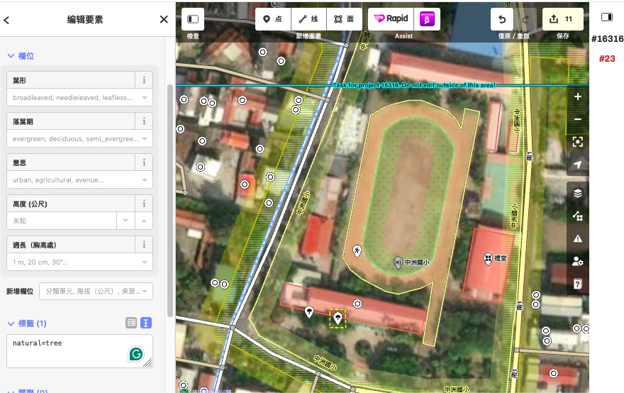
---
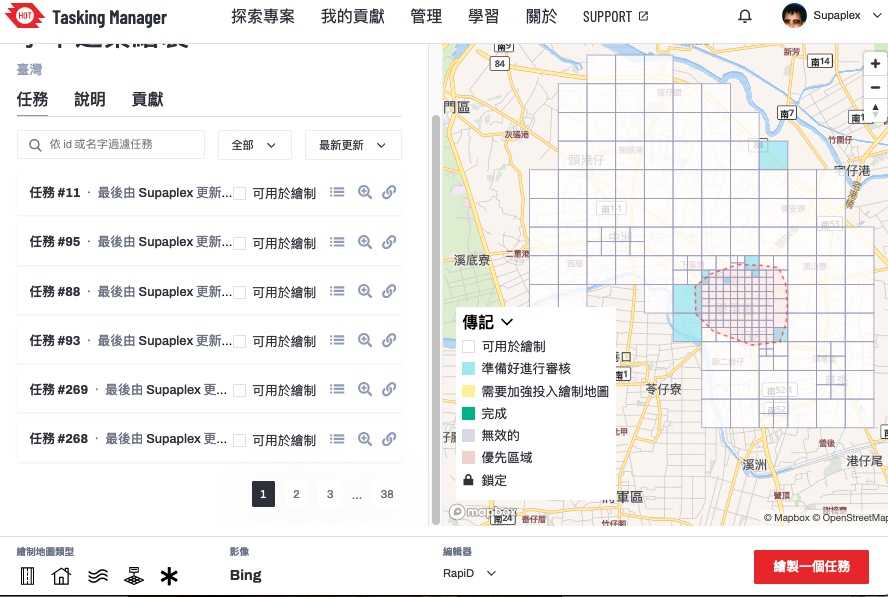
## HOT Tasking Manager 協調共同繪製地圖
<!-- .slide: data-background="https://upload.wikimedia.org/wikipedia/commons/thumb/8/86/OpenStreetMap_homepage_2022_en.png/640px-OpenStreetMap_homepage_2022_en.png" data-background-opacity="0.5"-->
---
## OSINT 實例
<!-- .slide: data-background="https://upload.wikimedia.org/wikipedia/commons/thumb/8/86/OpenStreetMap_homepage_2022_en.png/640px-OpenStreetMap_homepage_2022_en.png" data-background-opacity="0.5"-->
* 連江丹陽溪尾鎮的[解放軍基地](https://umap.openstreetmap.fr/zh-tw/map/by_77487?scaleControl=false&miniMap=false&scrollWheelZoom=false&zoomControl=true&editMode=disabled&moreControl=true&searchControl=null&tilelayersControl=null&embedControl=null&datalayersControl=true&onLoadPanel=none&captionBar=false&captionMenus=true)
---
## 來動手增進台灣圖資數量與品質吧!
<!-- .slide: data-background="https://upload.wikimedia.org/wikipedia/commons/thumb/8/86/OpenStreetMap_homepage_2022_en.png/640px-OpenStreetMap_homepage_2022_en.png" data-background-opacity="0.5"-->
* https://www.openstreetmap.org
---
## OSM x Wikidata 月聚
<!-- .slide: data-background="https://upload.wikimedia.org/wikipedia/commons/thumb/8/86/OpenStreetMap_homepage_2022_en.png/640px-OpenStreetMap_homepage_2022_en.png" data-background-opacity="0.5"-->
* 11/10 19:30 @[摩茲工寮](http://moztw.org/space/)
* Facebook [OpenStreetMap台灣](https://www.facebook.com/groups/OpenStreetMap.TW/)

---
## [To-siā!](https://en.wiktionary.org/wiki/%E5%A4%9A%E8%AC%9D#Chinese) [sṳ̀n-mùng-ǹ!](https://en.wiktionary.org/wiki/%E6%89%BF%E8%92%99%E4%BD%A0) Thank you! :sheep:
<!-- .slide: data-background="https://upload.wikimedia.org/wikipedia/commons/thumb/8/86/OpenStreetMap_homepage_2022_en.png/640px-OpenStreetMap_homepage_2022_en.png" data-background-opacity="0.5"-->
你可以在以下管道找到我
<div style="display:inline-flex;align-items:center;gap:2rem;">
<div style="flex:1;text-align:left" left>
- [GitHub](https://github.com/Supaplextw/)
- Supaplex: [Wikidata](https://wikidata.org/wiki/User:Supaplex),[OpenStreetMap](https://www.openstreetmap.org/user/Supaplex)
- 或是寄[電子郵件](mailto:dennis@wikimedia.tw)
</div>
<div style="flex:1;text-align:left" left>
* 臉書社團 Wikidata Taiwan
* 臉書社團 OpenStreetMap台灣
* OSM Wiki [Taiwan](https://wiki.openstreetmap.org/wiki/Taiwan)
</div>
</div>
{"description":"View the slide with \"Slide Mode\".","title":"離線圖資 Openstreetmap 的防災應用以及 OSINT 淺談","contributors":"[{\"id\":\"6d29f5f5-3da6-40f2-b920-e9a4cc2181dd\",\"add\":33964,\"del\":2906,\"latestUpdatedAt\":1762045401282}]"}