### In wenige Tage werden wir die [Bern in Minecraft](https://hack.data-hackdays-be.ch/project/66)-Challenge an der **[Data Hackdays BE](https://data-hackdays-be.ch)** lancieren. Ich übe mich mit Vorfreude, und teile ein paar Gedanken zum Thema, wie wir die echte Welt mit Voxels zu nachbauen beginnen.
Bern ist seit einigen Zeit schon grossartig in Alps BTE [nachgebaut geworden](https://www.youtube.com/watch?v=58vXP2GppKE) (YouTube). Es gab von drei Jahren ein kurzer Bericht dazu in [BärnToday](https://web.archive.org/web/20221003055817/https://www.baerntoday.ch/bern/stadt-bern/diese-berner-gebaeude-wurden-in-computerspiel-nachgebaut-147383387). Hier gibt es mehr Infos zum Projekt: https://alps-bte.com/en/
> Our Mission is to fully recreate Austria, Switzerland and Liechtenstein at a 1:1 scale in the video game Minecraft. -- AlpsBTE
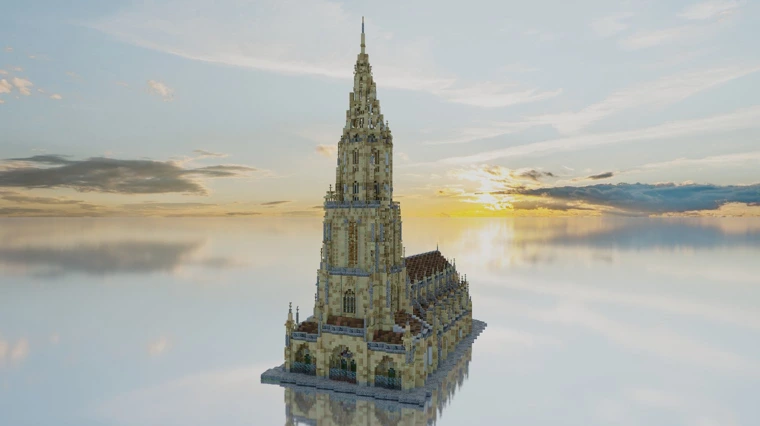
_Berner Münster - [Alps BTE Gallery](https://alps-bte.com/en/gallery)_
Bis Oktober sind diese Werke sogar in einer Ausstellung in Zürich besuchbar! [Musée Visionnaire](https://www.museevisionnaire.ch/landsichtssache/) ([Saaltext als PDF](https://www.museevisionnaire.ch/wp-content/uploads/MV_Landsichtssache_Saaltext_BTE.pdf), [Showcase auf YouTube](https://www.youtube.com/watch?v=P92ae8nyN-A)) :eyes:
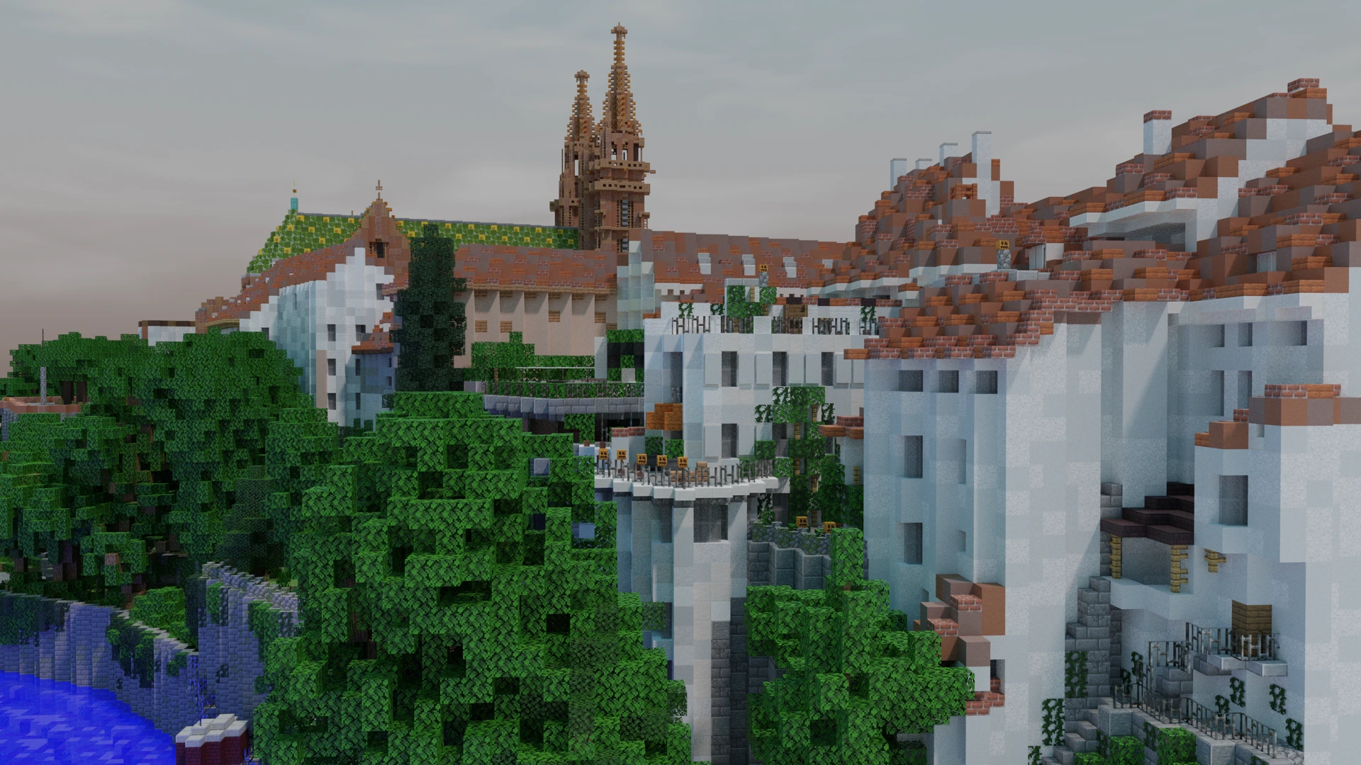
Es gibt noch viel Bedarf an Mitmacher\*innen die ein Haus oder zwei nachbauen wollen. Hier ist einen schönen Blick auf Basel:
Brodnay, Head of Community von Alps BTE, hat ein paar Quellen für Geodaten vorgeschlagen: [kgk-cgc.ch](https://www.kgk-cgc.ch/geodaten) und [swisstopo](https://map.geo.admin.ch/). Um sich virtuell in Bern aus unterschiedliche Winkel zu orientieren, neben bekannte Google-Produkte, werden auch empfohlen:
- [Der offizieller Stadtplan](https://map.bern.ch/stadtplan)
- [Interaktives Bern 360° Panorama](https://bern360.ch/Default_krpano_g.html)
- [360° Fotos und Videos von AirPano](http://www.airpano.com/360photo/bern-switzerland)
- [Bilder auf Strassenebene und Kartendaten von Mapillary](https://www.mapillary.com/app)
- [Historische Luftbilder auf Wikimedia Commons](https://commons.wikimedia.org/wiki/Category:Aerial_photographs_of_Switzerland_by_city)
# WorldPainter
An der Data Hackdays wollen wir uns vor allem mit automatisierter Konvertierung der verfügbaren Daten beschäftigen. Mit dem Tool WorldPainter könnte ich schon gut starten.
> [WorldPainter](https://www.worldpainter.net/) is an interactive graphical map generator for the game Minecraft. It offers tools similar to those of a normal paint program to shape and mould the terrain, paint materials, trees, snow and ice, etc. on top of it and much more.
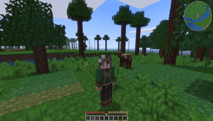
So habe ich heute Morgen ein kleines Stück Berner Oberland bespielbar gemacht:
1. Mit swissALTI3D meine Gemeinde heruntergeladen als GeoTIFF in 2m Auflösung
1. In QGIS der Datei / die Dateien eröffnen, prüfen, und als PNG Bilder exportieren.
1. In WorldPainter importieren, der Wasserniveau stellen (bei mir auf -50) und Startpunkt setzen.
1. Als Minecraft Map exportieren (eine Minute oder 2 warten ...)
1. In Minecraft eröffnen, Elytra anziehen, deine beliebten Landschaften erkennen.
> [swissALTI3D](https://www.swisstopo.admin.ch/en/height-model-swissalti3d#swissALTI3D---Download) is an extremely precise digital elevation model which describes the surface of Switzerland without vegetation and development. It is updated every six years.
Screenshots:


Der grösste Unterschied machen die Einstellungen beim Import new world > Import from height map

Ich kann dieser Hügel wo ich öfters jogge deutlich erkennen - es ist viel grösser und flacher in Wirklichkeit.

Der Rand meine Karte ist etwas surreal: Das liegt an dem, dass ich beim Export nicht auf eine quadratische Auflösung geachtet habe. Solche Fehler sind allerdings schnell korrigierbar in WorldPainter.

Auch mit der In-Game-Karte kann ich mich gut orientieren.

[Fornads Misty Mountains](https://www.reddit.com/r/Minecraft/comments/1kkp14z/my_best_results_with_mountains_in_minecraft_yet/)
So sieht es bei einem Profi aus! Fornad hat diese Fantasie-landschaft auch mit WorldPainter erstellt ([Kartenansicht](https://www.reddit.com/media?url=https%3A%2F%2Fi.redd.it%2Fh1m9wq4mdhdd1.png)). Bespielbar auf [Ardacraft](https://www.ardacraft.me/).

[Vales of Amoril](https://www.planetminecraft.com/project/vales-of-amoril/) ist ein Projekt in einer ähnlichen Richtung.
Weiteres in [/r/Worldpainter](https://www.reddit.com/r/Worldpainter/) und [minecraftforum.net](https://www.minecraftforum.net/search?search=worldpainter).
# Alternativen
[Gaming on Linux](https://www.gamingonlinux.com/2024/11/luanti-formerly-minetest-v5100-out-now-bringing-ui-updates-fancier-shaders-renaming-work/)
Für der Open Source Minecraft-Alternative **Luanti** gibt es eine [Anleitung im Forum](https://forum.luanti.org/viewtopic.php?f=11&t=12666). Aber ich denke, es wäre einfacher, die Minecraft Karte auf Luanti-Format zu [konvertieren mit mcimport](https://github.com/minetest-tools/mcimport).
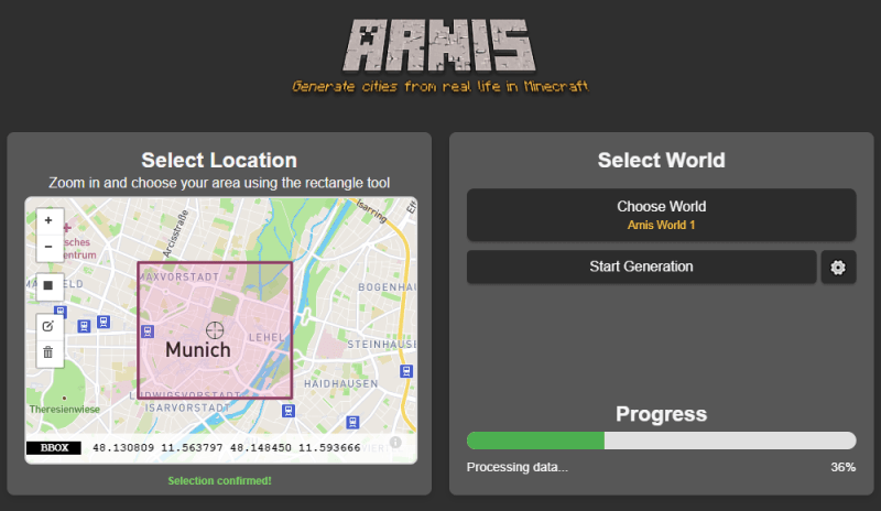
Und mit ARNIS / OpenStreetMap ist es noch einfacher, so wie [Hackaday berichtet](https://hackaday.com/2024/12/30/bringing-openstreetmap-data-into-minecraft/).
> Bringing OpenStreetMap Data Into Minecraft
Over the years, dedicated gamers have created incredible recreations of real (and not so real) locations and structures within the confines of Minecraft. -- Tom Nardi
[animalia-life.club](https://animalia-life.club/qa/pictures/minecraft-earth-map-to-scale)
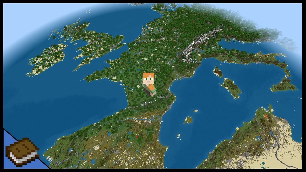
Auf [Minecraft Earth Map](https://earth.motfe.net/) ist es möglich, der ganzen Welt als riesige Karte zu herunterladen.
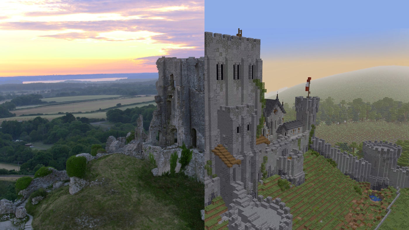
[Corfe Ruins - National Trust](https://www.nationaltrust.org.uk/discover/virtual-visit/explore-virtual-ruins-in-minecraft)
In Bildungsprojekte aus England ([National Trust](https://www.nationaltrust.org.uk/discover/virtual-visit/explore-virtual-ruins-in-minecraft)) und Kanada ([Electric Archaeology](https://electricarchaeology.ca/2014/09/30/historical-maps-topography-into-minecraft-qgis/)), wird es geklärt wie Minecraft Maps für Didaktik, bspw. für Geschichtsunterricht, verwendet soll.
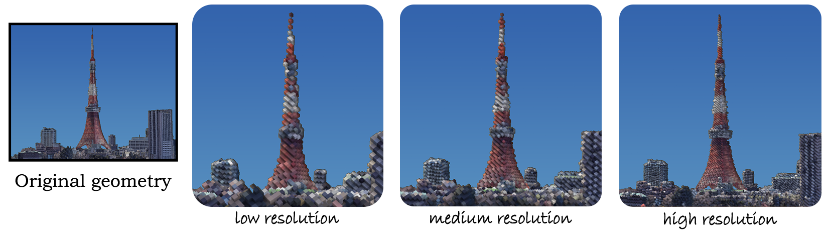
[Voxel Earth](https://voxelearth.org/) ist ein ziemlich spannender Ansatz aus aktueller KI-Forschung.
> 'Voxelizing Google Earth: A Pipeline for New Virtual Worlds' is a groundbreaking project that converts Google's Photorealistic 3D Tiles into voxel-based models, enabling immersive virtual worlds in Minecraft, VR, and web browsers.

[quantum_jim @ Reddit](https://www.reddit.com/r/Minetest/comments/br9lps/i_used_quantum_computation_to_make_terrain_for/)
Warum nicht eine Minecraft-Welt generieren mit [Quantum Computing](https://github.com/quantumjim/csv2terrain?tab=readme-ov-file)?

[Kiel, Deutschland - Geoboxers](https://geoboxers.com/worldbloxer/)
Es gibt auch bezahlbare Profi-Services, so wie https://geoboxers.com/worldbloxer/
> The real world in Minecraft. Get your map here. Based on real-world geospatial data. 2 km by 2 km maps from 50 USD.
# Zurück nach Bern
Hier ist der Altstadt von Bern in 1px ~= 1m Auflösung: [PNG](https://drive.proton.me/urls/NG4KCN8D40#dh6AR8zlM5ME), [GeoTIFF](https://drive.proton.me/urls/S719WMPPX8#jZe6JFkoEMrP) (2K x 1K), aus swisstopo swissalti3D Daten (Quellennennung erförderlich).
So sind die Daten heruntergeladen:

Mit QGIS und [GDAL](https://gdal.org/en/stable/download.html) können die GeoTIFF Raster-Layers zusammengefügt werden:

Merged Layer mit OpenStreetMap im Vorschau:

Optionen für optimalen Export:

Import Height Map in WorldPainter, nach kleine Korrekturen der Bilddaten in GIMP:

Erfolgreiches Exportprozedur:

Blick auf der Münsterplattform:

Gleichen Aussicht in [swisstopo GeoAdmin 3D](https://map.geo.admin.ch/#/map?lang=en&sr=3857&camera=7.449443,46.944999,612.9,-16,49,&3d&topic=ech&layers=&bgLayer=ch.swisstopo.pixelkarte-farbe):

Jetzt fehlen nur noch einige Häusern :bricks: Start building!
Ich bleibe gespannt auf die Ergebnisse, und freue mich, diese neue Welten nach Mass in einem Berner Minecraft-Server zu besuchen.
### _Viel Spass bei der Hackdays!_
# Data Hackdays Report
A short report of the Minecraft project at Data Hackdays. It was the largest and most energetic group, staying at the venue longer than everyone else, working until 11 PM on setting up a server and creating game resources.
We had a sub-group of 3 pre-teens who with their parents were doing some Alps BTE-inspired building activities on the side. For them we set up a plain server in Creative mode, and they started peacefully working on houses that they first sketched on paper.
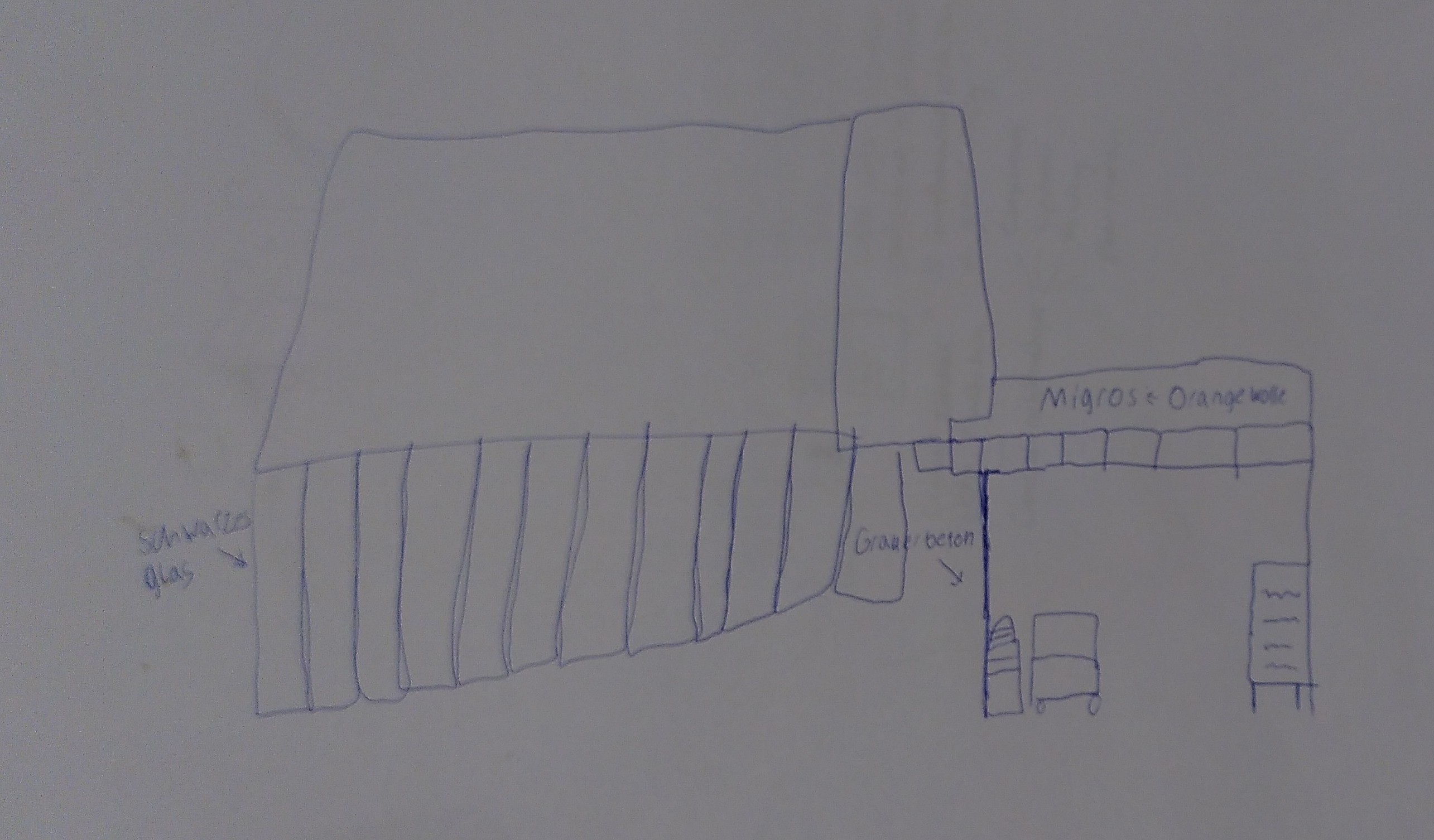
They picked these locations from the [Bern City Map](https://map.bern.ch/stadtplan/), and placed them roughly in the same location using the topographic map I set up for them.

We did not share the server address with anyone, but also did not take steps to password-protect it. Somehow, a griefer discovered the address, and disrupted our hackathon activities with a barrage of destructive actions - all while spamming us to sign up to a hosting service. Blurred out in the screenshot to avoid giving them free advertising:

An apocalyptic scene of desolation was all that remained of our first attempt to build Bern in Minecraft:

It's at that point that we had a serious discussion with the kids and team about what happened, and what steps we could have taken to prevent this. First of all, nobody of us actually had Ops, so the only way to kick out the griefer was to shut down the server. We could have much more quickly reacted and banned a strange account with a swift `/kick`:

Secondly, there are whitelist options, where the allowed accounts are pre-defined. Thirdly, we could set a password using a plugin. We decided to change the port of the server from the standard to one that was only known to us, and from that point no more griefers dropped in on us.
What we also discussed with the kids was the value of backups, and made sure that in the following build rounds we regularly zipped up our progress. There are also tools to do this within the game, namely the [Clone command](https://minecraft.fandom.com/wiki/Commands/clone) and various plugins, but they are not very convenient.
Finally, we would follow the Build the Earth project's lead here, and lock down parts of the map to certain accounts, or even restrict all normal user accounts from editing the map.
Before they where whisked away to some healthier outdoor activities in the sunny weather, we made some screenshots of the second version of our kids builds, including this entryway into the shopping centre with redstone controlled sliding doors:

A comfortable underground bunker with hot pool and TV lounge:


Dramatic scenes at sunset and night:


