--- image: https://encrypted-tbn0.gstatic.com/images?q=tbn:ANd9GcQoE3MVp02BCyR3UnQfd2kqeT80ei3IUxbOZg&usqp=CAU --- # ArcMap 台灣常見座標轉換流程 ###### tags: `ArcGIS` `ArcMap` `座標轉換` 在ArcToolbox中有個 「**Create Custom Geographic Transformation**」 工具,可以提供使用者自訂座標系統轉換參數。台灣的使用者可以透過該工具自訂TWD67、TWD97、WGS84三種常見座標系統的轉換參數,設定好的轉換參數檔案(\*.gtf)預設放在以下目錄,使用者可以自行複製到其他電腦使用。 **C:\\Users\\<user>\\AppData\\Roaming\\ESRI\\Desktop<版本>\\ArcToolbox \\CustomTransformations** 設定完畢之後,定義為TWD67、TWD97、WGS84座標系統的地理資料,就可以使用 「**Project**」 工具,套用設定好的轉換參數進行座標系統轉換。因此使用ArcMap進行座標轉換流程可分為以下兩大步驟: 1.使用 「Create Custom Geographic Transformation」 建立轉換公式 2.使用 「Project」 對地理資料進行座標系統轉換 以下將針對上述兩步驟進行詳述。 ## 建立轉換公式 ### 建立TWD67 -- TWD97 座標轉換參數 1. 在ArcToolbox中開啟 「Create Custom Geographic Transformation」 工具,工具位於**Data Management Tools** > **Projections and Transformations**底下 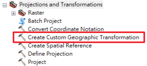 2. 依照以下資料輸入對應的參數值,並點選 「OK」 即可建立完成 | 參數名稱 | 參數值 | |------------------------------------- |-------------------- | | Geographic Transformation Name | TWD67 -- TWD97 | | Input Geographic Coordinate System | TWD_1967_TM_Taiwan | | Output Geographic Coordinate System | TWD_1997_TM_Taiwan | | Method | Coordinate Frame | 【轉換參數】 | X Axis Translation (meters) | X軸平移量(公尺) | 730.160 | |----------------------------- |----------------- |------------------------------------ | | Y Axis Translation (meters) | Y軸平移量(公尺) | 346.212 | | Z Axis Translation (meters) | Z軸平移量(公尺) | 472.186 | | X Axis Rotation (seconds) | X軸旋轉量(秒) | 7.968009465325332199694565793688 | | Y Axis Rotation (seconds) | Y軸旋轉量(秒) | 3.5498173155125282722429064796627 | | Z Axis Rotation (seconds) | Z軸旋轉量(秒) | 0.40634166830677981965825251394163 | | Scale Difference (ppm) | 尺度參數 | 0.99998180 | 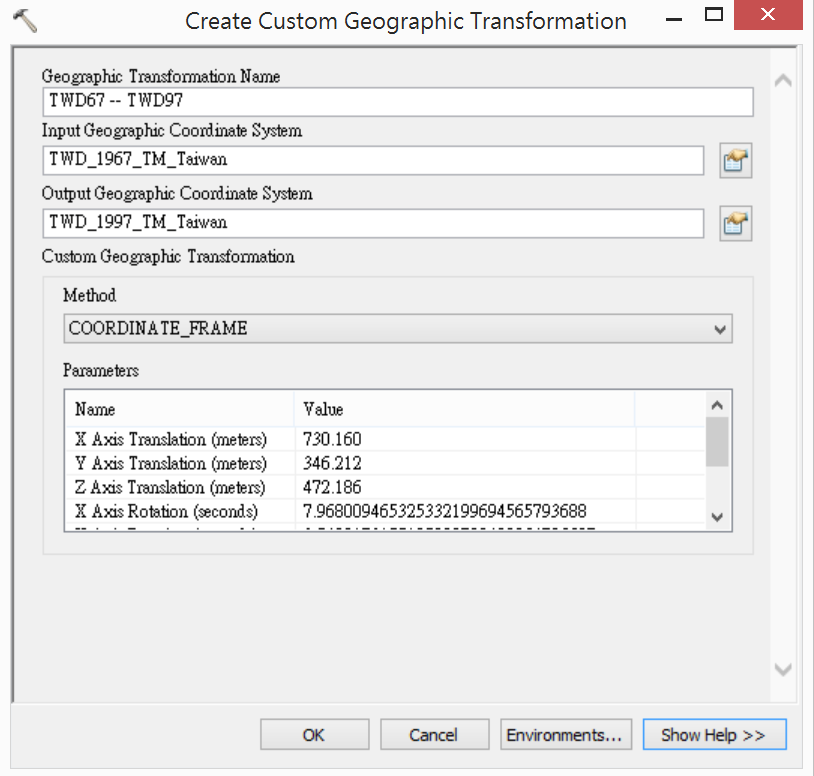 ### 轉換方法與參數說明 本文所提及的轉換方法是根據Help中的說明,Coordinate Frame法與台灣地區常用的Bursa-Wolf法在程式引擎當中是一樣的,所以在設定時選擇Coordinate Frame法。 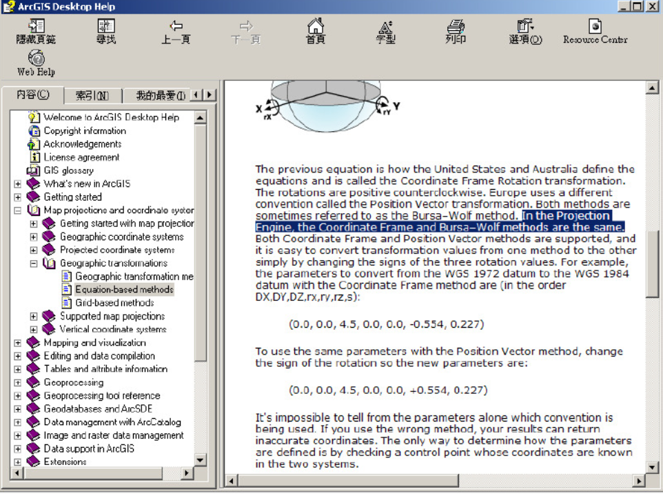 轉換參數則是使用史天元老師等人於**測量工程第41卷第3期**所發表的 「TWD67與TWD97大地基準轉換方法研究」 一文中所提及的七參數Bursa-Wolf基準轉換參數,並將旋轉量單位徑換算為秒(因為Create Custom Geographic Transformation工具需要輸入秒)後所得的數值。在 「TWD67與TWD97大地基準轉換方法研究」 一文中,有提到**經計算所得的七參數會有誤差,因此轉換結果也會有誤差**。 ### 建立TWD97 – WGS84 座標轉換參數 1. 在ArcToolbox中開啟 「Create Custom Geographic Transformation」 工具,工具位於***Data Management Tools* > *Projections and Transformations***底下  2. 依照以下資料輸入對應的參數值,並點選 「OK」 即可建立完成 | 參數名稱 | 參數值 | |------------------------------------- |------------------------ | | Geographic Transformation Name | TWD97 -- WGS84 | | Input Geographic Coordinate System | TWD_1997_TM_Taiwan | | Output Geographic Coordinate System | GCS_WGS_1984 | | Method | GEOCENTRIC_TRANSLATION | 【轉換參數】 | Name | Value | |----------------------------- |------- | | X Axis Translation (meters) | 0 | | Y Axis Translation (meters) | 0 | | Z Axis Translation (meters) | 0 | ### 轉換方法與參數說明 由EPSG 7.1版資料庫中查詢得知TWD97與WGS84的轉換方式名稱為 「TWD97 to WGS84」 ,編號是 「3830」 ,使用地區為 「台灣,中華民國,近陸與近海,台灣島、澎湖(澎湖群島)島」 ,轉換精度為 「1」 公尺。 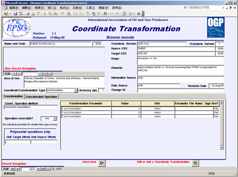  註記當中說明了 「近似值有正負一公尺的水準,假設TWD97近似於WGS84的話」 。資料來源為 「OGP(International Association of Oil & Gas producers,國際油氣製造業協會)。  座標轉換方法名稱 「地理中心轉移」 。轉換參數有三個, 「X軸轉移為0」 、 「Y軸轉移為0」 、 「Z軸轉移為0」 ,且該轉換是可進行逆向轉換的。  由以上描述內容可得,TWD97經緯度基本上等同於WGS84經緯度,因為X軸、Y軸、Z軸的平移皆為0 ## 座標轉換 1. 在ArcToolbox中開啟 「Project」 工具,工具位於 ***Data Management Tools \\ Projections and Transformations*** 底下  2. 只要 「Input Coordinate System」 與 「Output Coordinate System」 互為`TWD67`、`TWD97`、`WGS84`,就可以在 「Geographic Transformation」 的下拉選單中,選擇建立好的轉換公式。 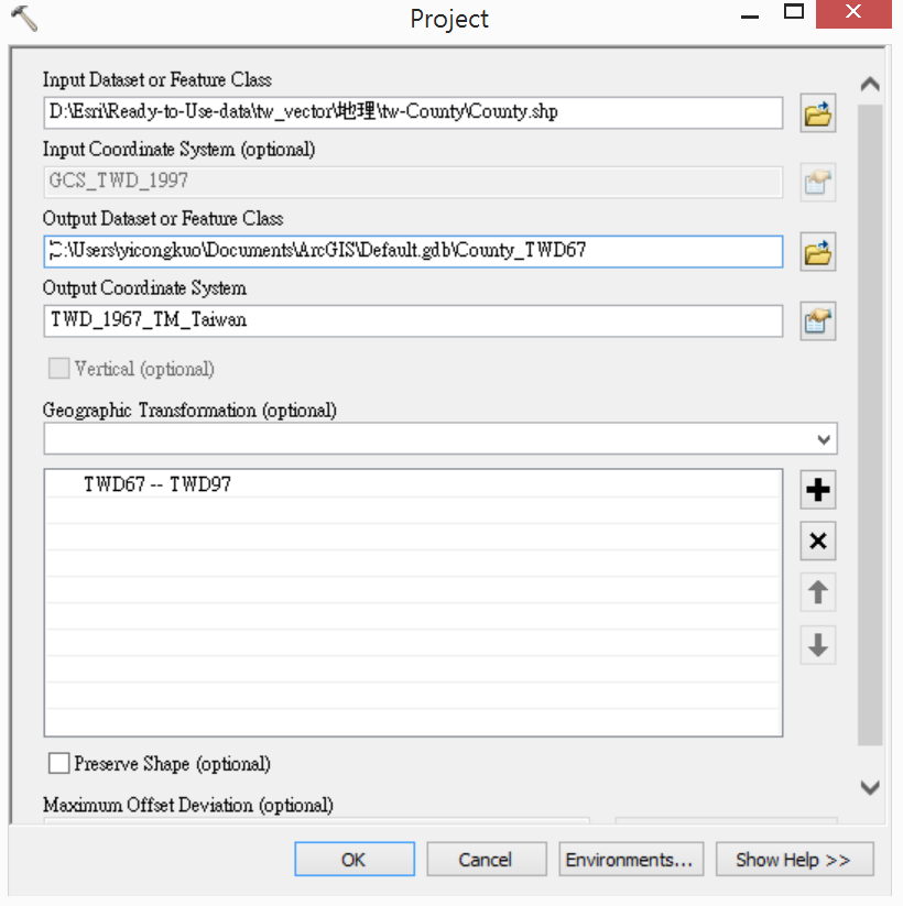 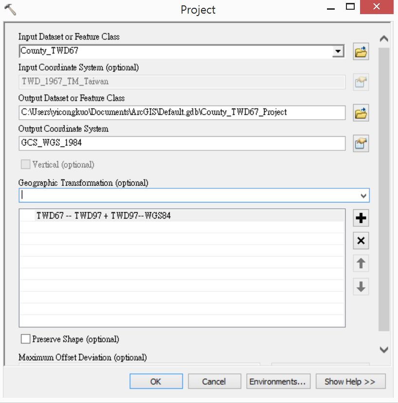 3. 按下 「OK」 完成座標轉換 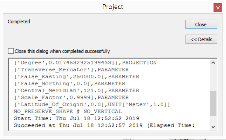 ### 在ArcMap中加入不同座標系統的地理資料 使用ArcMap時如果加入不同座標系統的地理資料,ArcMap一般會跳出警告訊息,如下圖。 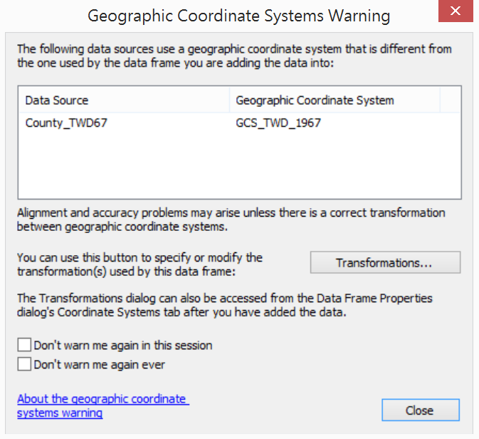 如果此時按下 「Transformation」 按鈕,也可以指定要使用的轉換參數 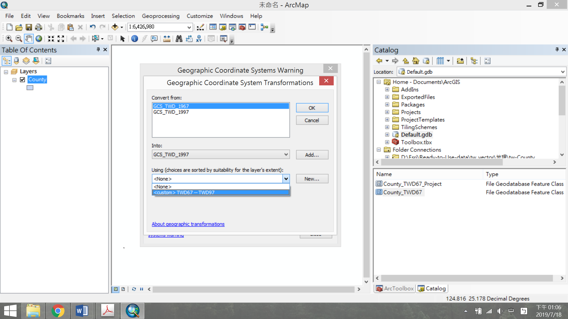 ## TWD97與TWD67轉換結果比較 當比例尺要放到很大,會發現TWD97與TWD67地理資料會有誤差。利用 「Measure」 工具量測,視地區不同,誤差約一公尺左右。 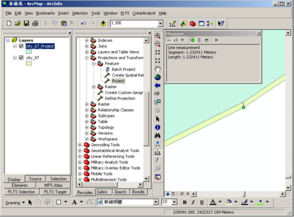
×
Sign in
Email
Password
Forgot password
or
Sign in via Google
Sign in via Facebook
Sign in via X(Twitter)
Sign in via GitHub
Sign in via Dropbox
Sign in with Wallet
Wallet (
)
Connect another wallet
Continue with a different method
New to HackMD?
Sign up
By signing in, you agree to our
terms of service
.